Search Results
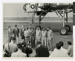
Photograph of Howard Hughes and others in front of the XH-17 helicopter, Culver City, California, October 23, 1952
Date
1952
Archival Collection
Description
Howard Hughes (second from left) standing in front of the experimental helicopter XH-17, Flying Crane, with others (from left to right): Rea Hopper, Director of the Aeronautical Division, Hughes Aircraft Company; Hughes; Clyde Jones, Director of Engineering, Hughes Tool Company Aeronautical Division; Warren Reed, Assistant; Colonel Carl E. Jackson from Air Research and Development Headquarters, Baltimore; Gale J. Moore, Pilot; possibly Chal Bowen, Flight Engineer/Co-pilot; and an unidentified man, October 23, 1952.
Image
Lewis, Fred, Letizia & Lewis publicity with president at City Hall, 1989 March 16
Level of Description
File
Archival Collection
Frank Mitrani Photographs
To request this item in person:
Collection Number: PH-00332
Collection Name: Frank Mitrani Photographs
Box/Folder: Box 29
Collection Name: Frank Mitrani Photographs
Box/Folder: Box 29
Archival Component

City of Las Vegas map, 1952
Date
1952
Description
General information on Las Vegas and index on verso ; Copyright held by Redwood Publishing Co. ; Includes inset map of the Strip (U.S. 91 or Los Angeles Highway) ; Redwood Publishing Company
Text
Howard Hughes sitting in his XF-11 near Culver City, California, 1946
Level of Description
File
Archival Collection
Howard Hughes Public Relations Photograph Collection
To request this item in person:
Collection Number: PH-00373
Collection Name: Howard Hughes Public Relations Photograph Collection
Box/Folder: Folder 22
Collection Name: Howard Hughes Public Relations Photograph Collection
Box/Folder: Folder 22
Archival Component
Hugh H. Brown Papers
Identifier
MS-00883
Abstract
The Hugh Henry Brown Papers consist of professional and personal papers (1902-1927) from Hugh Henry Brown, who was a lawyer in Tonopah, Nevada. The professional communication focuses on Brown's law practice dealing primarily with mining and railroad companies in Central Nevada. The papers also contain receipts from purchases made by Brown or his wife, Marjorie Moore Brown.
Archival Collection