Search Results

Map of California, Utah, Nevada, Colorado, New Mexico and Arizona, 1864
Date
1864
Description
'Johnson's California, with Utah, Nevada, Colorado, New Mexico, and Arizona, published by Johnson and Ward.' 'Entered according to Act of Congress in the Year 1864 by A.J. Johnson in the Clerks Office of the District Court of the United States for the southern district of New York.' Atlas page numbers in upper margin: 66-67. This is probably plate 67 from Johnson's New Illustrated Family Atlas, published in New York by Johnson & Ward in 1864. Shows natural features, locations of Indian tribes, proposed railroad routes, routes of explorers, trails, county boundaries and populated places ; "." ; Relief shown by hachures ; Prime meridians: Greenwich and Washington ; In top margin: 66-67 ; Hand colored ; On verso: Historical and statistical view of Mexico and central America (p. 79) and Historical and statistical view of the United States, 1860 (p. 78) Scale [ca. 1:3,484,800]. 1 in. to ca. 55 miles (W 124°--W 102°/N 42°--N 32°)
Text
Structural drawings, as existing sheets S2.2-S15.65, 1980 July 15
Level of Description
File
Scope and Contents
This set includes drawings by Independent, Sykes, Kiker, and Thomas (manufacturer).
Archival Collection
Martin Stern Architectural Records
To request this item in person:
Collection Number: MS-00382
Collection Name: Martin Stern Architectural Records
Box/Folder: Roll 444
Collection Name: Martin Stern Architectural Records
Box/Folder: Roll 444
Archival Component
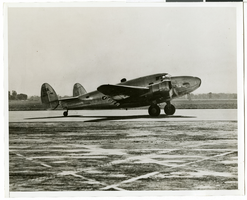
Photograph of the Lockheed 14 aircraft, Fairbanks, Alaska, July 15, 1938
Date
1938-07-15
Archival Collection
Description
The black and white view of the Lockheed 14 aircraft preparing for a part of Howard Hughes' Around the World flight. Description printed on photograph's accompanying sheet of paper: "Howard Hughes world flight plane in S. Paul, Minn., for 33-minute stop before last leg of flight back to New York."
Image
#69247: New faculty members on August 15, 2013, 2013 August 15
Level of Description
File
Archival Collection
University of Nevada, Las Vegas Creative Services Records (2010s)
To request this item in person:
Collection Number: PH-00388-05
Collection Name: University of Nevada, Las Vegas Creative Services Records (2010s)
Box/Folder: Digital File 00
Collection Name: University of Nevada, Las Vegas Creative Services Records (2010s)
Box/Folder: Digital File 00
Archival Component

City map of Las Vegas, 1973
Date
1905-05-26
Description
Color; 55 x 45 cm., on sheet 95 x 47 cm., folded to 24 x 10 cm. Panel title: Las Vegas city map. Copyright held by Cardinal Publishing Company. Relief shown by hachures. Includes illustrations and advertisements. Index, text, illustrations, advertisements, and map of "Lake Mead National Recreation Area, lower basin section" on verso. Original publisher: Cardinal Publishing Company.
Image
Report: "Marketing Casino Gambling and a Local Lottery in New York City" by the Council of the City of New York for the Committee on Economic Development, 1991
Level of Description
File
Archival Collection
Eugene Martin Christiansen Papers
To request this item in person:
Collection Number: MS-00561
Collection Name: Eugene Martin Christiansen Papers
Box/Folder: Box 163
Collection Name: Eugene Martin Christiansen Papers
Box/Folder: Box 163
Archival Component
Photograph of Howard Hughes in the first XF-11, Culver City, California, 1946
Date
1946
Archival Collection
Description
Howard Hughes in the cockpit of his XF-11 airplane before his first test flight.
Image
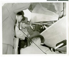
Photograph of Howard Hughes behind his plane at Le Bourget Airfield, France, July 1938
Date
1938-07
Archival Collection
Description
Description printed on photograph's accompanying strip of paper: "Howard Hughes examining the damaged tail of his plane after his arrival at the Le Bourget Airfield, Paris, on his world flight. July 1938"
Image

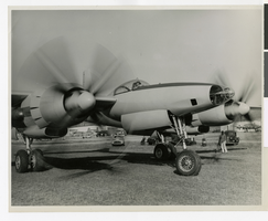
Photograph of Howard Hughes's plane taking off, Minneapolis, Minnesota, July 14, 1938
Date
1938-07-14
Archival Collection
Description
The black and white view of the Lockheed 14 aircraft taking off on a part of Howard Hughes' Around the World flight. Typed onto a piece of paper attached to the image: "The Howard Hughes plane taking off from Minneapolis on their way to New York to complete a round the world flight."
Image

Map of the territories of New Mexico, Arizona, Colorado, Nevada, and Utah, 1855
Date
1855
Description
29 x 36 cm. Relief shown by hachures. Prime meridians: Greenwich and Washington. "Entered according to act of Congress in the year 1855 by J.H. Colton & Co. in the Clerk's Office of the Dist. Office of the U.S. for the Southern. Dist. of New York." Hand colored. Decorative border. Atlas p. number in lower-right margin: 67. Shows routes of explorers, proposed railroad routes, wagon route, mail route, Indian reserves and mines. On verso: History and statistical view of Mexico. Original publisher: J.H. Colton.
Image