Search Results
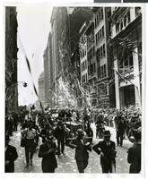
Photograph of a parade procession, New York, July 15, 1938
Date
1938-07-15
Archival Collection
Description
A view looking down Broadway during the parade procession to celebrate Howard Hughes' completion of his round-the-world flight.
Image
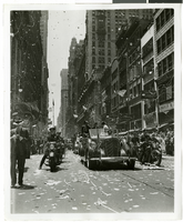
Photograph of a parade procession, New York, July 15, 1938
Date
1938-07-15
Archival Collection
Description
A view looking down Broadway during the parade procession to celebrate Howard Hughes' completion of his round-the-world flight.
Image
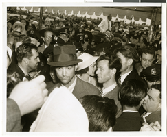
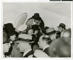
Photograph of Howard Hughes at Floyd Bennett Airfield, New York, July 14, 1938
Date
1938-07-14
Archival Collection
Description
The black and white view of Howard Hughes, surrounded by crowds, after landing his Lockheed 14 aircraft for the Around the World flight at Floyd Bennett Airfield in New York. Description printed on photograph's accompanying sheet of paper: "Howard Hughes at Floyd Bennett Field after his round the world flight, 7-14-38. (Press Association)"
Image
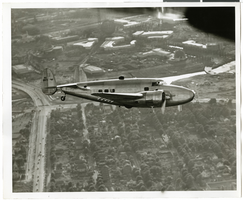
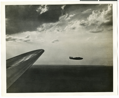
Photograph of the Lockheed 14 aircraft over New York City, July 1938
Date
1938-07
Archival Collection
Description
The black and white view of Howard Hughes plane in flight over New York City, July 1938
Image
Photograph of the Lockheed 14 aircraft over New York City, July 1938
Date
1938-07
Archival Collection
Description
The black and white view of Howard Hughes plane in flight over New York City, July 1938
Image

Photograph of Howard Hughes and other men, New York, July 14, 1938
Date
1938-07-14
Archival Collection
Description
Description printed on photograph's accompanying sheet of paper: "Group at [Gover] Whalen's home 7/14/38. (Daily News)." Howard Hughes is standing third from the left.
Image
Photograph of Howard Hughes at Floyd Bennett Airfield, New York, July 1938
Date
1938-07-14
Archival Collection
Description
The black and white view of Howard Hughes, surrounded by crowds, as he exited his Lockheed 14 at Floyd Bennett Airfield.
Image

Map of California and territories of New Mexico and Utah, circa 1861
Date
1856 to 1866
Description
40 x 60 cm. Relief shown by hachures and spot heights. Prime meridians: Greenwich and Washington. Atlas plate numbers 54 and 55 in the upper corners. Shows forts, trails, exploration routes, drainage, mail steamship routes, physical features, Indian tribes, and historic sites. The geographic region of Southwest is referred to as the New Southwest. Original publisher: Johnson .
Image
Howard Hughes being interviewed by reporters in New York, New York, 1946 September 12
Level of Description
File
Archival Collection
Howard Hughes Public Relations Photograph Collection
To request this item in person:
Collection Number: PH-00373
Collection Name: Howard Hughes Public Relations Photograph Collection
Box/Folder: Folder 22
Collection Name: Howard Hughes Public Relations Photograph Collection
Box/Folder: Folder 22
Archival Component