Search Results
Howard Hughes in the cockpit of the XF-11, 1946 July 07
Level of Description
File
Archival Collection
Howard Hughes Professional and Aeronautical Photographs
To request this item in person:
Collection Number: PH-00321
Collection Name: Howard Hughes Professional and Aeronautical Photographs
Box/Folder: Folder 08
Collection Name: Howard Hughes Professional and Aeronautical Photographs
Box/Folder: Folder 08
Archival Component
Edward J. Kelly, Mayor of Chicago, and Howard Hughes, 1938 July
Level of Description
File
Archival Collection
Howard Hughes Public Relations Photograph Collection
To request this item in person:
Collection Number: PH-00373
Collection Name: Howard Hughes Public Relations Photograph Collection
Box/Folder: Folder 14
Collection Name: Howard Hughes Public Relations Photograph Collection
Box/Folder: Folder 14
Archival Component
Howard Hughes walking with several men in France, 1938 July
Level of Description
File
Archival Collection
Howard Hughes Public Relations Photograph Collection
To request this item in person:
Collection Number: PH-00373
Collection Name: Howard Hughes Public Relations Photograph Collection
Box/Folder: Folder 06
Collection Name: Howard Hughes Public Relations Photograph Collection
Box/Folder: Folder 06
Archival Component
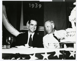
Photograph of Howard Hughes and Noah Dietrich, Houston, Texas, July 30, 1939
Date
1938-07-30
Archival Collection
Description
Howard Hughes (left) Noah Dietrich at a Hughes Tool Company celebration in Houston, Texas in 1939.
Image
Car transporting Howard Hughes and others, 1938 July 21
Level of Description
File
Archival Collection
Howard Hughes Public Relations Photograph Collection
To request this item in person:
Collection Number: PH-00373
Collection Name: Howard Hughes Public Relations Photograph Collection
Box/Folder: Folder 13
Collection Name: Howard Hughes Public Relations Photograph Collection
Box/Folder: Folder 13
Archival Component
Crowd gathered for the Howard Hughes parade, 1938 July 15
Level of Description
File
Archival Collection
Howard Hughes Public Relations Photograph Collection
To request this item in person:
Collection Number: PH-00373
Collection Name: Howard Hughes Public Relations Photograph Collection
Box/Folder: Folder 10
Collection Name: Howard Hughes Public Relations Photograph Collection
Box/Folder: Folder 10
Archival Component
Howard Hughes in Grover Whalen's car, 1938 July 15
Level of Description
File
Archival Collection
Howard Hughes Public Relations Photograph Collection
To request this item in person:
Collection Number: PH-00373
Collection Name: Howard Hughes Public Relations Photograph Collection
Box/Folder: Folder 11
Collection Name: Howard Hughes Public Relations Photograph Collection
Box/Folder: Folder 11
Archival Component
Howard Hughes during parade procession, 1938 July 15
Level of Description
File
Archival Collection
Howard Hughes Public Relations Photograph Collection
To request this item in person:
Collection Number: PH-00373
Collection Name: Howard Hughes Public Relations Photograph Collection
Box/Folder: Folder 11
Collection Name: Howard Hughes Public Relations Photograph Collection
Box/Folder: Folder 11
Archival Component