Search Results
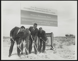
Senators Howard Cannon, Alan Bible, and two unidentified men shoveling at a new construction site: photographic print
Date
1950 (year approximate) to 1983 (year approximate)
Archival Collection
Description
From the Howard Cannon Photograph Collection (PH-00192). The group participate in the groundbreaking "New Research Facility for Edgerton, Germshausen and Grier - Airport Industrial Tract"
Image
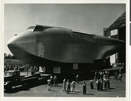
Photograph of the fuselage of the Howard Hughes' Flying Boat, Culver City, California, 1946
Date
1946
Archival Collection
Description
A section of Howard Hughes' "Spruce Goose" or "Flying Boat" being moved (with a police escort) from the Hughes Aircraft plant in Culver City, California to Terminal Island in the Los Angeles Harbor where the plane was assembled in June of 1946.
Image
Howard Hughes with a group of men inside the Hughes Tool Company shop in Houston, Texas, 1938 July 30
Level of Description
File
Archival Collection
Howard Hughes Professional and Aeronautical Photographs
To request this item in person:
Collection Number: PH-00321
Collection Name: Howard Hughes Professional and Aeronautical Photographs
Box/Folder: Folder 04
Collection Name: Howard Hughes Professional and Aeronautical Photographs
Box/Folder: Folder 04
Archival Component
Howard Hughes, N. E. Boehm, and an unidentified man examining machinery in the Hughes Tool Company plant, 1938 July 30
Level of Description
File
Archival Collection
Howard Hughes Professional and Aeronautical Photographs
To request this item in person:
Collection Number: PH-00321
Collection Name: Howard Hughes Professional and Aeronautical Photographs
Box/Folder: Folder 06
Collection Name: Howard Hughes Professional and Aeronautical Photographs
Box/Folder: Folder 06
Archival Component
Alexander Troyanovsky, Soviet Ambassador to the U.S., and Howard Hughes at the Moscow Airdrome, Moscow, Russia, 1938 July 12
Level of Description
File
Archival Collection
Howard Hughes Professional and Aeronautical Photographs
To request this item in person:
Collection Number: PH-00321
Collection Name: Howard Hughes Professional and Aeronautical Photographs
Box/Folder: Folder 06
Collection Name: Howard Hughes Professional and Aeronautical Photographs
Box/Folder: Folder 06
Archival Component
Edward Lund, Howard Hughes, Harry Connor, and Lieutenant Thomas Thurlow, Houston, Texas, 1938 July 30
Level of Description
File
Archival Collection
Howard Hughes Professional and Aeronautical Photographs
To request this item in person:
Collection Number: PH-00321
Collection Name: Howard Hughes Professional and Aeronautical Photographs
Box/Folder: Folder 06
Collection Name: Howard Hughes Professional and Aeronautical Photographs
Box/Folder: Folder 06
Archival Component
Howard Hughes surrounded by a crowd at Le Bourget Field in France in front of a Lockheed-14, 1938 July 11
Level of Description
File
Archival Collection
Howard Hughes Professional and Aeronautical Photographs
To request this item in person:
Collection Number: PH-00321
Collection Name: Howard Hughes Professional and Aeronautical Photographs
Box/Folder: Folder 04
Collection Name: Howard Hughes Professional and Aeronautical Photographs
Box/Folder: Folder 04
Archival Component
Howard Hughes being escorted by police in a hangar located at the Grand Central Air Terminal in Los Angeles, 1938
Level of Description
File
Archival Collection
Howard Hughes Public Relations Photograph Collection
To request this item in person:
Collection Number: PH-00373
Collection Name: Howard Hughes Public Relations Photograph Collection
Box/Folder: Folder 15
Collection Name: Howard Hughes Public Relations Photograph Collection
Box/Folder: Folder 15
Archival Component
Howard Hughes being carried ashore at the U.S. Coast Guard Station, Jamaica Bay, 1938 January 15
Level of Description
File
Archival Collection
Howard Hughes Public Relations Photograph Collection
To request this item in person:
Collection Number: PH-00373
Collection Name: Howard Hughes Public Relations Photograph Collection
Box/Folder: Folder 03
Collection Name: Howard Hughes Public Relations Photograph Collection
Box/Folder: Folder 03
Archival Component