Search Results
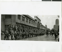
Photograph of police men awaiting the arrival of Howard Hughes, New York, July 15, 1938
Date
1938-07-15
Archival Collection
Description
Typed onto a piece of paper attached to the image: "Police lined up ready for the start of Howard Hughes parade. 7/15/38."
Image
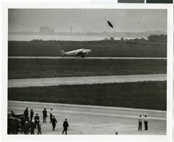
Photograph of the landing of Howard Hughes' Lockheed 14 aircraft, New York, July 14, 1938
Date
1938-07-14
Archival Collection
Description
The black and white, aerial view of Howard Hughes' Lockheed 14 aircraft performing its final landing on the Round the World flight at Floyd Bennett Airport, New York.
Image
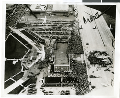
Crowd standing outside City Hall while Howard Hughes and his crew get their picture taken in celebration of Hughes's completion of his around-the-world flight in New York City, 1938 July 15
Level of Description
File
Archival Collection
Howard Hughes Public Relations Photograph Collection
To request this item in person:
Collection Number: PH-00373
Collection Name: Howard Hughes Public Relations Photograph Collection
Box/Folder: Folder 12
Collection Name: Howard Hughes Public Relations Photograph Collection
Box/Folder: Folder 12
Archival Component
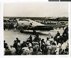
Photograph of the landing of Howard Hughes' Lockheed 14 aircraft, New York, July 14, 1938
Date
1938-07-14
Archival Collection
Description
The black and white view of Howard Hughes' Lockheed 14 aircraft performing its final landing on the Round the World flight at Floyd Bennett Airport, New York. Typed onto a piece of paper attached to the image: "Howard Hughes taxiing up runway at Floyd Bennett Airport."
Image
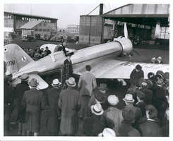
Photograph of Howard Hughes leaving the Northrop Gamma Racer, Newark, New Jersey, January 13, 1936
Date
1936-01-13
Archival Collection
Description
Howard Hughes leaving the cockpit of a Northrop Gamma, surrounded by a crowd at Newark New Jersey Airport. Hughes set a coast-to-coast speed record. A bank of microphones and a movie camera are seen beside the plane.
Image

Photograph of Howard Hughes and Grover Whalen at Floyd Bennett Airfield, New York, July 14, 1938
Date
1938-07-14
Archival Collection
Description
A view of Howard Hughes and Grover Whalen at Floyd Bennett Airfield in New York. Description printed on photograph's accompanying sheet of paper: "Howard Hughes leaving Floyd Bennett Airport after completing a round the world flight with four companions. He is leaving with Grover Whalen (Left in picture) 7-14-38. (Press Association)."
Image