Search Results

Map of California, Utah, Nevada, Colorado, New Mexico and Arizona, circa 1867
Date
1865 to 1869
Description
39 x 56 cm. Relief shown by hachures. "Entered according to act of Congress in the year 1864, by A.J. Johnson in the Clerks Office of the United States for the Southern District of New York." Atlas page numbers in upper margin: 67-68. Primer meridians: Greenwich and Washington, D.C. On verso: History and statistical view of the West India islands or Columbian Archipelago and Historical and statistical view of Mexico and Central America. Shows proposed railroads, locations of Indian tribes, natural features, counties, mines, mail routes, trails and routes of exploring expeditions. Has decorative border. Southern part of Nevada was added to the state in 1867 and is part of Nevada on this map, but Lincoln County was established in 1867 and is not on this map. This map was still probably published in 1867 in spite of someone's having written "1864" in pencil in the lower right corner of the Library's copy. Original publisher: A.J. Johnson.
Image
Los Angeles Mayor Frank L. Shaw, Howard Hughes, and California Governor Frank Merriam dining together at a banquet for Howard Hughes in Los Angeles, California, 1938 August 01
Level of Description
File
Archival Collection
Howard Hughes Public Relations Photograph Collection
To request this item in person:
Collection Number: PH-00373
Collection Name: Howard Hughes Public Relations Photograph Collection
Box/Folder: Folder 16
Collection Name: Howard Hughes Public Relations Photograph Collection
Box/Folder: Folder 16
Archival Component
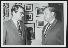
Elliott Richardson, new ambassador to Britain meets with Howard Cannon in his Washington, D.C. office: photographic print
Date
1950 (year approximate) to 1983 (year approximate)
Archival Collection
Description
From the Howard Cannon Photograph Collection (PH-00192)
Image

Plan of proposed new well pipe and fittings for Las Vegas, Nevada, 1936
Date
1936
Archival Collection
Description
Blueprint. Written on back of map:: 'Purposed [sic] new transmission lines--1936--transits.' Las Vegas Land and Water Company?
Image
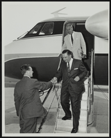
Howard Cannon visits Grumman Aircraft Engineering Plant at Bethpage, Long Island, New York: photographic print
Date
1962-08
Archival Collection
Description
From the Howard Cannon Photograph Collection (PH-00192)
Image
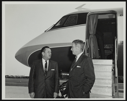
Howard Cannon visits Grumman Aircraft Engineering Plant at Bethpage, Long Island, New York: photographic print
Date
1962-08
Archival Collection
Description
From the Howard Cannon Photograph Collection (PH-00192)
Image
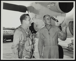
Howard Cannon visits Grumman Aircraft Engineering Plant at Bethpage, Long Island, New York: photographic print
Date
1962-08
Archival Collection
Description
From the Howard Cannon Photograph Collection (PH-00192)
Image
Crowd of Hughes Tool Company employees holds a welcome rally for Howard Hughes in Houston, Texas, 1938 July 30
Level of Description
File
Archival Collection
Howard Hughes Professional and Aeronautical Photographs
To request this item in person:
Collection Number: PH-00321
Collection Name: Howard Hughes Professional and Aeronautical Photographs
Box/Folder: Folder 06
Collection Name: Howard Hughes Professional and Aeronautical Photographs
Box/Folder: Folder 06
Archival Component
Howard Hughes being interviewed by media before beginning his around-the-world flight attempt, 1938 July 10
Level of Description
File
Archival Collection
Howard Hughes Professional and Aeronautical Photographs
To request this item in person:
Collection Number: PH-00321
Collection Name: Howard Hughes Professional and Aeronautical Photographs
Box/Folder: Folder 06
Collection Name: Howard Hughes Professional and Aeronautical Photographs
Box/Folder: Folder 06
Archival Component