Search Results
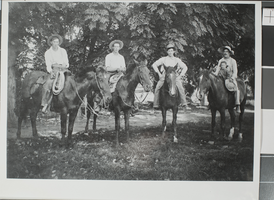
Photograph of men on horseback at Kiel Ranch, Las Vegas, June 30, 1924
Date
1924-06-30
Archival Collection
Description
A group of men on horseback at Kiel Ranch in Northern Las Vegas, Nevada. The Las Vegas Review Journal published this photo in their segment "Help Us Write History," and a reader responded with the following description: "Left: Francesco Barravecchio. Rider nest to left: Salvatore Bencivengo. Horseman - (second from RGT): Mario Lasalnullovo. Extreme Right: Pasquale Spensieri and 5 yr old daughter Filomrna. Photo taken: June 30th, 1924. Why: Summer Vacation." This document is included with the image.
Image
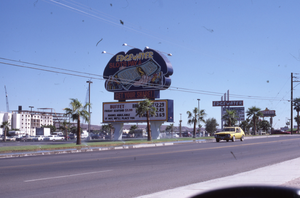
Edgewater Casino Resort double mounted pylon sign, Laughlin, Nevada: photographic print
Date
1986
Archival Collection
Description
The exterior view of the (now defunct) sign for the Edgewater Casino Resort during the day.
2020 S Casino Dr, Laughlin, NV 89029
Image
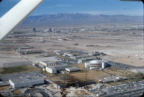
Slide of aerial view of University of Nevada, Las Vegas campus, circa 1971
Date
1970 to 1972
Archival Collection
Description
Aerial view, looking west, of University of Nevada, Las Vegas campus. Round building is Dickinson Library. Building in lower left is Moyer Student Union. Building under construction in foreground is Flora Dungan Humanities building. The Dunes Hotel, Caesars Palace, and the Sands Hotel can be seen in the distance.
Image

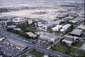
Slide of aerial view of University of Nevada, Las Vegas campus, circa 1983
Date
1981 to 1985
Archival Collection
Description
Aerial view, looking east, of University of Nevada, Las Vegas campus. Round and rectangular buildings connected by red tunnel is Dickinson Library. Harmon Ave. is seen in the foreground.
Image
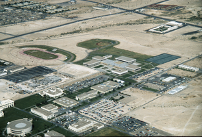
Slide of aerial view of University of Nevada, Las Vegas campus, circa 1983
Date
1981 to 1985
Archival Collection
Description
Aerial view, looking southwest, of University of Nevada, Las Vegas campus. Maryland Parkway is seen in the foreground. The Thomas & Mack Center is seen in the center distance.
Image

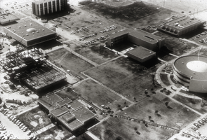
Slide of aerial view of University of Nevada, Las Vegas campus, circa 1963-1966
Date
1963 to 1966
Archival Collection
Description
Partial aerial view, looking west, of University of Nevada, Las Vegas (then Nevada Southern University) campus. The Gymnasium is at the left, the library building is in the center and the Fong Geoscience Building is at the right (all with deep shadows to the east). A small parking lot is next to the library.
Image
Slide of aerial view of University of Nevada, Las Vegas campus, circa 1971-1972
Date
1970 to 1972
Archival Collection
Description
Partial aerial view, looking southwest of the University of Nevada, Las Vegas campus. Construction on the Flora Dungan Humanities Building is seen at the left center.
Image
Slide of aerial view of University of Nevada, Las Vegas campus, circa 1975-1976
Date
1974 to 1976
Archival Collection
Description
Partial aerial view, looking west, of University of Nevada, Las Vegas campus, showing construction on the Juanita Greer White Life Sciences building (gray building near center right of photo).
Image

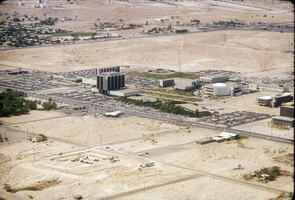
Slide of aerial view of University of Nevada, Las Vegas campus, circa 1972-1975
Date
1972 to 1975
Archival Collection
Description
Aerial view, looking southwest, of the University of Nevada, Las Vegas campus. Maryland Parkway is in the center of the photo.
Image
Slide of aerial view of University of Nevada, Las Vegas campus, circa 1972-1975
Date
1972 to 1975
Archival Collection
Description
Partial aerial view, looking southwest, of the University of Nevada, Las Vegas campus. Maryland Parkway is in the center of the photo.
Image