Search Results
March to Los Angeles: L.A. City Hall, Culinary Union, 1992 (folder 1 of 1), image 6
Date
Description
Image

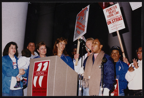
March to Los Angeles: L.A. City Hall, Culinary Union, 1992 (folder 1 of 1), image 8
Date
Description
Image
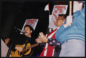
March to Los Angeles: L.A. City Hall, Culinary Union, 1992 (folder 1 of 1), image 9
Date
Description
Image
"Howard Hughes the Aviator" Sub-Master with Code, 1986 April 15
Level of Description
Archival Collection
Collection Name: Hughes Electronics Corporation Records
Box/Folder: Box 12
Archival Component
The Picture Room, at Benevolent Hall. London: printed and sold by Howard and Evans, approximately 1800 to 1819
Level of Description
Archival Collection
Collection Name: Mavis Eggle "Books as They Were Bought" Collection
Box/Folder: Box 27
Archival Component
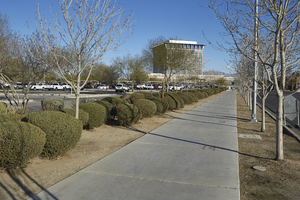
A sidewalk leads to the North Las Vegas City Hall, looking north in North Las Vegas, Nevada: digital photograph
Date
Archival Collection
Description
From the UNLV University Libraries Photographs of the Development of the Las Vegas Valley, Nevada (PH-00394). Part of the collection documents the entire 19 mile length of the north/south Eastern Avenue / Civic Center Drive alignment. This photograph was captured in the section of Civic Center Drive between Las Vegas Boulevard and Lake Mead Boulevard.
Image
Mark Hall-Patton oral history interview
Identifier
Abstract
Oral history interview with Mark Hall-Patton conducted by Stefani Evans and Claytee D. White on August 25, 2016 for the Building Las Vegas Oral History Project. Hall-Patton discusses coming to Las Vegas, Nevada in 1993, creating the Howard W. Cannon Aviation Museum, and becoming a director for Clark County Museums in 2008, just when the economic downturn caused large layoffs and a drop in visitor numbers. He also talks about how joining the television show
Archival Collection
#70747: Hospitality student Melinda Stewart at the Hospitality Hall construction site on March 15, 2016., 2016 March 15
Level of Description
Archival Collection
Collection Name: University of Nevada, Las Vegas Creative Services Records (2010s)
Box/Folder: Digital File 00
Archival Component
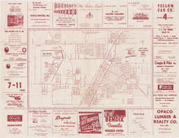
Map of the city of Las Vegas, 1953
Date
Description
Image
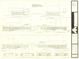
Architectural drawing of concert hall and drama theater, University of Nevada, Las Vegas, exterior elevations, November 5, 1969
Date
Archival Collection
Description
Exterior elevations for the concert hall and drama theater on the University of Nevada, Las Vegas campus, including a connecting courtyard. These buildings would become the Artemus W. Ham Concert Hall and the Judy Bayley Theatre. Sheet 6 of 35. "Drawn by G.T. Checked by K.D. Job number 6828. Scale 1/16" = 1'-0". Date Nov. 5, 1969"
Site Name: University of Nevada, Las Vegas
Address: 4505 S. Maryland Parkway
Image