Search Results
New York Mine, Silver City, Nevada, undated
Level of Description
File
Archival Collection
Mary Griffith Toleno Photograph Collection
To request this item in person:
Collection Number: PH-00021
Collection Name: Mary Griffith Toleno Photograph Collection
Box/Folder: Folder 01
Collection Name: Mary Griffith Toleno Photograph Collection
Box/Folder: Folder 01
Archival Component
Harbor reports - New York City map, 1925
Level of Description
File
Archival Collection
Union Pacific Railroad Collection
To request this item in person:
Collection Number: MS-00397
Collection Name: Union Pacific Railroad Collection
Box/Folder: Box 53
Collection Name: Union Pacific Railroad Collection
Box/Folder: Box 53
Archival Component
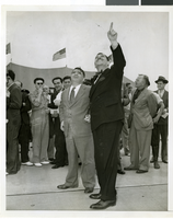
Photograph a crowd awaiting watching Howard Hughes land, New York, July 14, 2013
Date
1938-07-14
Archival Collection
Description
The black and white view Mayor Laguardia and Grover Whelen watched Howard Hughes land in his Lockheed 14 aircraft at Floyd Bennett Field, New York. Typed onto a piece of paper attached to the image: "Mayor Laguardia (left) and Grover Whelen looking skyward as they see the approaching Howard Hughes and his globe girdlers complete A Round The World flight, 7-24-38. (Press Association)."
Image
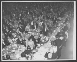
Photograph of a formal dinner at the Hotel Astor, New York City, 1958
Date
1958
Archival Collection
Description
A Formal dinner at the Hotel Astor in New York City, 1958. Wilbur Clark is located at the center of the picture, leaning his elbow on the table to the right. (Credit: Bill Mark, Park Sheraton Hotel, NYC.)
Image
Harrah's Grand, Atlantic City, New Jersey, 2001
Level of Description
File
Archival Collection
Robert Beckmann Photographs
To request this item in person:
Collection Number: PH-00381
Collection Name: Robert Beckmann Photographs
Box/Folder: Box 02
Collection Name: Robert Beckmann Photographs
Box/Folder: Box 02
Archival Component
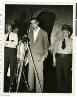
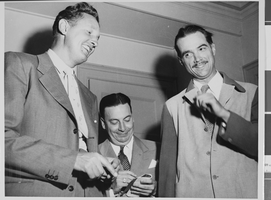
Photograph of Howard Hughes at a press conference beside his Douglas DC-3, New York, April, 1947
Date
1947-04
Archival Collection
Description
Howard Hughes giving a news Conference beside his airplane after landing in New York. This was his first flight after the nearly fatal XF-11 prototype crash in 1946.
Image
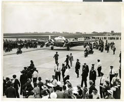
Photograph of the landing of Howard Hughes' Lockheed 14 aircraft, New York, July 14, 1938
Date
1938-07-14
Archival Collection
Description
The black and white view of Howard Hughes' Lockheed 14 aircraft performing its final landing on the Round the World flight at Floyd Bennett Airport, New York.
Image

Map of California, with territories of Utah, Nevada, Colorado, New Mexico, and Arizona, 1864
Date
1864
Description
40 x 62 cm. Relief shown by hachures. Prime meridians: Greenwich and Washington. Page numbers at top: 58-59. "Entered according to act of Congress in the year 1864 by A. J. Johnson in the Clerk's Office of the District Court of the United States for the Southern District of New York." Original publisher: Johnson and Ward.
Image
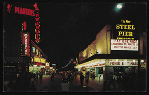
Nighttime view of Atlantic City, New Jersey: postcard
Date
1940 (year approximate) to 1990 (year approximate)
Archival Collection
Description
From Harvey's Hotel and Casino Postcard Collection (PH-00367)
Image
Photograph of Howard Hughes with Senator Harry P. Cain, Culver City, California, August 16, 1947
Date
1947-08-16
Archival Collection
Description
A view of Howard Hughes (right) being asked about his controversial XF-11 photo reconnaissance plane by Senator Harry Cain (left), Republican of Washington, in Culver City, California. An unidentified man sits between the two.
Image