Search Results
City Robber
Level of Description
File
Archival Collection
Guide to the Canadian Film Centre Worldwide Short Film Festival Submissions
To request this item in person:
Collection Number: MS-00615
Collection Name: Guide to the Canadian Film Centre Worldwide Short Film Festival Submissions
Box/Folder: Box 2006-021
Collection Name: Guide to the Canadian Film Centre Worldwide Short Film Festival Submissions
Box/Folder: Box 2006-021
Archival Component
City Window
Level of Description
File
Archival Collection
Guide to the Canadian Film Centre Worldwide Short Film Festival Submissions
To request this item in person:
Collection Number: MS-00615
Collection Name: Guide to the Canadian Film Centre Worldwide Short Film Festival Submissions
Box/Folder: Box 2006-017
Collection Name: Guide to the Canadian Film Centre Worldwide Short Film Festival Submissions
Box/Folder: Box 2006-017
Archival Component
In the City, Missing
Level of Description
File
Archival Collection
Guide to the Canadian Film Centre Worldwide Short Film Festival Submissions
To request this item in person:
Collection Number: MS-00615
Collection Name: Guide to the Canadian Film Centre Worldwide Short Film Festival Submissions
Box/Folder: Box 2002-030
Collection Name: Guide to the Canadian Film Centre Worldwide Short Film Festival Submissions
Box/Folder: Box 2002-030
Archival Component
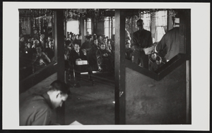
Volunteers of the Civilian Conservation Corps celebrating Christmas in the recreation hall of their camp in Boulder City, Nevada: photographic print
Date
1939-12
Archival Collection
Description
From the T.M. Parsons Photograph Collection (PH-00258) -- Recreation hall at camp number NP-6, Company 2536 Former Six Companies'.
Image
L. City, 2002
Level of Description
File
Archival Collection
Guide to the Canadian Film Centre Worldwide Short Film Festival Submissions
To request this item in person:
Collection Number: MS-00615
Collection Name: Guide to the Canadian Film Centre Worldwide Short Film Festival Submissions
Box/Folder: Box 2003-005
Collection Name: Guide to the Canadian Film Centre Worldwide Short Film Festival Submissions
Box/Folder: Box 2003-005
Archival Component
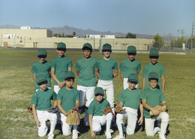
Photograph of Boulder City Rotary Little League team, Boulder City, Nevada, 1987
Date
1987
Archival Collection
Description
The Boulder City Rotary Little League team posing for a photograph in Boulder City, Nevada.
Image
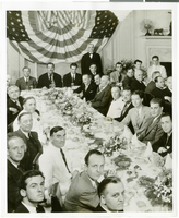
Photograph of a luncheon for the completion of Howard Hughes' Round the World flight, New York City, July 15, 1938
Date
1938-07-15
Archival Collection
Description
Typed onto a piece of paper attached to the image: "Fete, Hughes, and crew at Luncheon. Left to right at the head of the table are Harry P. Connor, navigator of the Hughes plane, Grover Whalen, Howard hughes, Mayor Fiorello Laguardia of New York City, Thomas Thurlow, Navigator, Richard Stoddart, radio engineer, and Edward Lund, flight engineer. At the bottom center of the photo is William Randolph Hearst, Jr., son of the publisher. 7/15/38"
Image
Boulder City, Nevada photographs, 1930-1969
Level of Description
Series
Scope and Contents
Materials contain photographic prints, photographic slides, and photographic negatives of Boulder City, Nevada from 1930 to 1969. The photographs depict buildings in Boulder City, including City Hall, the Bureau of Reclamation headquarters, the Boulder Theatre, the Boulder Dam Hotel, the Boulder City airport, the Visitors Bureau, businesses, and houses.
Archival Collection
L. F. Manis Photograph Collection
To request this item in person:
Collection Number: PH-00100
Collection Name: L. F. Manis Photograph Collection
Box/Folder: N/A
Collection Name: L. F. Manis Photograph Collection
Box/Folder: N/A
Archival Component
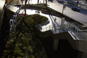
Modern city design aesthetic of City Center, Las Vegas, Nevada: digital photograph
Date
2016-11-08
Archival Collection
Description
Morning light defines the modern city design aesthetic at City Center as a pedestrian traverses the walkway.
Image
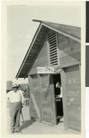
Photograph of the Boulder City Post Office and postmaster, Boulder City, Nevada, circa 1931
Date
1931
Archival Collection
Description
Black and white photograph of Boulder City Post Office and postmaster, Mr. Finney, at Boulder City.
Image