Search the Special Collections and Archives Portal
Search Results
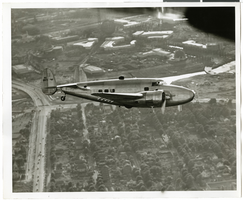
Photograph of the Lockheed 14 aircraft over New York City, July 1938
Date
1938-07
Archival Collection
Description
The black and white view of Howard Hughes plane in flight over New York City, July 1938
Image
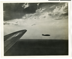
Photograph of the Lockheed 14 aircraft over New York City, July 1938
Date
1938-07
Archival Collection
Description
The black and white view of Howard Hughes plane in flight over New York City, July 1938
Image
T-Shirt Color: White; Front: Carson City Fire Dept., Fire Dept. Emblem W/ Fire Equipment & City Capital Building; Back: Carson City Firefighters, Fire & Rescue, Fire Truck In Front Of City Capital Building, approximately 2001-2012
Level of Description
File
Archival Collection
New York-New York Hotel and Casino 9-11 Heroes Tribute Collection
To request this item in person:
Collection Number: MS-00459
Collection Name: New York-New York Hotel and Casino 9-11 Heroes Tribute Collection
Box/Folder: Box 382
Collection Name: New York-New York Hotel and Casino 9-11 Heroes Tribute Collection
Box/Folder: Box 382
Archival Component
Boulder City, Nevada maps, drawings, and brochures, 1930 to 1998
Level of Description
Series
Scope and Contents
The Boulder City, Nevada maps, drawings, and brochures series (1930-1998) depicts Boulder City's early planning and development in the 1930s as well as the later development between the 1950s and 1980s. The series also includes maps of Boulder City after its incorporation in 1960 and advertisement posters from Boulder City organizations.
Archival Collection
UNLV University Libraries Collection of Boulder City, Hoover Dam, and Lake Mead National Recreation Area Maps and Brochures
To request this item in person:
Collection Number: MS-00955
Collection Name: UNLV University Libraries Collection of Boulder City, Hoover Dam, and Lake Mead National Recreation Area Maps and Brochures
Box/Folder: N/A
Collection Name: UNLV University Libraries Collection of Boulder City, Hoover Dam, and Lake Mead National Recreation Area Maps and Brochures
Box/Folder: N/A
Archival Component

Photograph of a house, Carson City, Nevada, circa 1920s
Date
1920 to 1929
Archival Collection
Description
Exterior of a house in Carson City. Advertising signs appear on the side of the house, suggesting the lower story may be a business.
Image
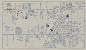
Street map of the city of Las Vegas, 1955
Date
1955
Description
20 x 35 cm., folded to 22 x 11 cm. Copyright held by Redwood Pub. Co. "Compliments of 'Buck' Evans 76 Union"--Panel. Index on verso. Includes table of mileages to Las Vegas from other cities in the Southwest. Original publisher: Redwood Publishing Co., Scale: .
Image
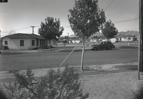
Film transparency of Boulder City, Nevada, circa 1931-1940
Date
1931 to 1940
Archival Collection
Description
Photograph of the residential area of Boulder City.
Image
City Center Motel at night, 1986
Level of Description
File
Archival Collection
Neon in Nevada Photograph Collection
To request this item in person:
Collection Number: PH-00225
Collection Name: Neon in Nevada Photograph Collection
Box/Folder: Binder PB-005
Collection Name: Neon in Nevada Photograph Collection
Box/Folder: Binder PB-005
Archival Component
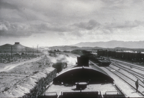
Slide of moving train, Boulder City, Nevada, circa 1930s
Date
1930 to 1939
Archival Collection
Description
A black and white image of a train taken near the Six Companies yard north of Boulder City, heading south. Information from back of photo or photo sleeve states "First passenger train entering Boulder City," however, the train is going in the wrong direction.
Image
Pagination
Refine my results
Content Type
Creator or Contributor
Subject
Archival Collection
Digital Project
Resource Type
Year
Material Type
Place
Language
Records Classification

