Search Results
Sales material for the Granada model home in the El Encanto development, Las Vegas, Nevada, 1967-1969
Date
Archival Collection
Description
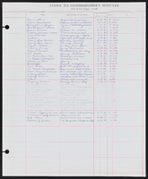
Sales material from the late 1960s for model no. 15 A residential home, called "The Granada," in the El Encanto development, Las Vegas, Nevada. One side has an illustration of the front exterior elevation, a floor plan, and a list of features. The other side shows two alternate exterior elevation illustrations (15A-3-L and 15A-1-R). The price is handwritten. The development is located between Harmon and Tropicana Avenues (north and south) and Sandhill Rd. (west) and S. Lamb Blvd. (east).
Site Name: El Encanto (Las Vegas, Nevada)
Text
Sales material for the Valencia model home in the El Encanto development, Las Vegas, Nevada, 1967-1969
Date
Archival Collection
Description
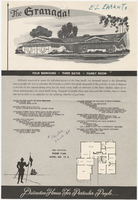
Sales material from the late 1960s for model no. 15 B residential home, called "The Valencia," in the El Encanto development, Las Vegas, Nevada. One side has an illustration of the front exterior elevation, a floor plan, and a list of features. The other side shows two alternate exterior elevation illustrations (15B-3-R and 15B-2-R). The price is handwritten. The development is located between Harmon and Tropicana Avenues (north and south) and Sandhill Rd. (west) and S. Lamb Blvd. (east).
Site Name: El Encanto (Las Vegas, Nevada)
Text
Sales material for the Conquistador model home in the El Encanto development, Las Vegas, Nevada, 1967-1969
Date
Archival Collection
Description
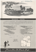
Sales material from the late 1960s for model no. 15 C residential home called "The Conquistador," in the El Encanto development, Las Vegas, Nevada. One side has an illustration of the front exterior elevation, a floor plan, and a list of features. The other side shows two alternate exterior elevation illustrations (15C-1-L and 15C-2-R). The price is handwritten. The development is located between Harmon and Tropicana Avenues (north and south) and Sandhill Rd. (west) and S. Lamb Blvd. (east).
Site Name: El Encanto (Las Vegas, Nevada)
Text
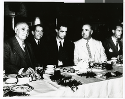
Photograph of Howard Hughes seated at banquet table, circa 1930s
Date
Archival Collection
Description
Image
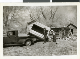
Photograph of Corn Creek Ranch, Nevada, circa 1938
Date
Archival Collection
Description
Image
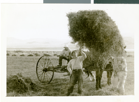
Photograph of Corn Creek Ranch, Nevada, circa 1938
Date
Archival Collection
Description
Image

Plat of H.F.M & M addition to city of Las Vegas, Clark County, Nevada, comprising the west 1/2 of N.W. 1/4 Sec. 27, Twp. 20 S., R. 61 E., M.D.B & M, March 8, 1924
Date
Description
Image
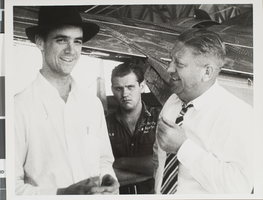
Photograph of Howard Hughes and other men, circa late 1930s
Date
Archival Collection
Description
Image