Search Results
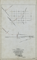
Map showing water pipeline in Arden, Nevada, May 4, 1913
Date
1913-05-04
Archival Collection
Description
'Exhibit A. S.P.L.A. & S.L.R.R. Los Angeles Division.' 'Approved May 4, 1913 [signed] E.M. Jessup, E.M. of W.' 'I-T-54.'
Image
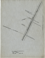
Map showing water pipeline serving H. C. Wheeler, Arden, Nevada, November 1929
Date
1929-11
Archival Collection
Description
Hand-drawn map. '2-W-214' hand-printed in lower right corner. Scale: 1" = 400'.
Image
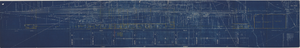
Map showing possible industrial users' connections to railroad pipelines in Las Vegas Nevada, circa 1930-1931
Date
1926 to 1936
Archival Collection
Description
Map showing industrial users' connections to railroad pipelines in Las Vegas, Nevada.
Image
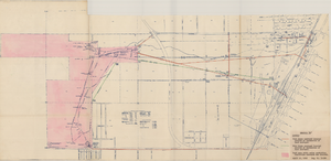
Map of Las Vegas Valley Water District, April 16, 1953
Date
1953-04-16
Archival Collection
Description
'Exhibit A.' 'April 16, 1953. Dwg, No. I-128.' Accompanies: Bill of Sale - LA&SL L.S.D. Audit No. 5251, Contract Dept. No. 39722-3 (Box 25 Folder 80-12).
Image
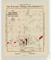
Map of the Bullfrog Mining District, Nye County, Nevada, circa 1905
Date
1901 to 1909
Description
At top of map: 'Compliments of the Forward Mining Development Co.' On left and right margins: 'The Patrick Investment Company, Fiscal Agents.' At bottom of map: '19 Toltec Block, Denver, Colorado.' 'The Williamson-Haffner Co., Denver.' Relief shown by hachures. Properties owned by Patrick Investment Company are marked in red. Shows railroads, roads, and pipelines. Scale [ca. 1:39,000. 1 in. to approx. 3,250 feet].
Image
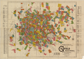
Map of U.S. patent and location surveys in the Goldfield Mining District, Esmeralda and Nye Counties, Nevada, 1907
Date
1907
Description
'Elmer J. Chute, E.M. and Olmstead & Rich. U.S. Deputy Mineral Surveyors, 1907. Copyright 1907 by Elmer J. Chute, E.M., Goldfield, Nev.' Includes index Includes township and range grid. Scale [ca. 1:22,800. 1 in. to approx. 1900 feet]
Text

Map of Argentite Red Mountain Mining District, Esmeralda County, Nevada, circa 1908-1913
Date
1908 to 1913
Description
'Compiled by C. A. Liddell, U.S. Mineral Surveyor, Tonopah, Nevada, from surveys by Sherwin, Giles and Liddell.' Published between 1908-1913? Scale [ca. 1:7,200]. 1 in. equals 600 feet. Map printed on linen.
Image
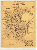
Map of Searchlight mining district, Clark County, Nevada, circa 1905
Date
1901 to 1909
Description
At bottom right of map: 'C.D. Baker, A.R. Thompson.' Title in lower right corner: 'Map of Searchlight mining district: mineral patents, water rights.' Logo of Nevada Engineering Construction Service, Inc., Las Vegas, Nev. in lower right corner. Blueline print. Shows mineral patents and water rights. Nevada Engineering & Construction Service, Inc.
Image
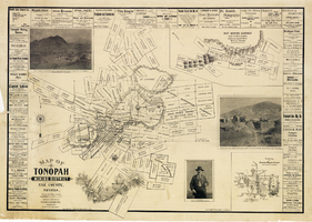
Map of Tonopah Mining District, Nye County, Nevada, 1902
Date
1902
Description
'Compiled and published by Booker & Bradford, engineers, Tonopah, Nevada.' 'Copyrighted by Booker & Bradford 1902.' 'Lith. Britton & Rey, S.F., Cal.' Relief shown by hachures. Includes insets of Ray Mining District, Nye County, Nevada, and Vicinity map of Tonopah Mining District, Nye County, Nevada. Includes advertisements and photographs of Tonopah ore, town of Tonopah, and of J.L. Butler, discoverer of the Mizpah Lode. Scale [ca. 1:7,200]. 1 inch to 600 feet. Mounted on linen.
Text
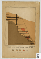
Vertical cross-section of Eureka Consolidated Mine, 1883
Date
1883
Description
'G. F. Becker, geologist-in-charge. Julius Bien & Co. lith. Mapping and geology by J. S. Curtis.' 'U.S. Geological Survey. Annual report 1883, pl. XXXIII.' Published by U.S. Geological Survey. Scale [ca. 1:2,400] 1 in.=200 feet. Library's copy has "Nev." printed in pencil in upper right corner.
Image