Search Results
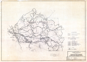
Regional map showing main air, highway, bus and railroad transportation, October 30, 1945
Date
1945-10-30
Description
50 x 70 cm. Blue-line print. Shows Arizona, western New Mexico, southwestern Utah, southern Nevada, and southern California. Also shows irrigation projects constructed and under construction. "Oct. 30, 1945. Rev. 2-14-46." "Drawn and traced by F. R. M." Original publishser: Bureau of Reclamation, Region III.
Image

Map of Las Vegas Valley artesian basin, circa 1940
Date
1938 to 1942
Description
Scale [ca. 1:72,000. 1 in.=approx. 6,000 feet] (W 115°10´--W 115°/N 36°20´--N 36´). Shows wells, springs, boundary between valley fill and bedrock, and ground water district boundaries for Las Vegas Metropolitan Area and North Las Vegas. "Figure 1." Nevada. State Engineer
Image
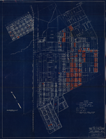
Map showing general plan for the district boundary of Lateral Sanitary Sewer District No. 1, Las Vegas, Nevada, circa 1928
Date
1925 to 1932
Description
' Webster L. Benham, consuting engineer.' 'Sheet 1 of 13.' Scale [ca. 1:3,600. 1 inch to approximately 300 feet]. Blueprint. Plat map. Library's copy has various areas colored in with red pencil. City of Las Vegas.
Image

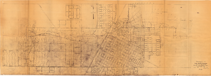
Map of major subdivisions near downtown Las Vegas, Nevada, circa 1931
Date
1928 to 1935
Archival Collection
Description
Map shows deed number and date of deed for some public properties and location and composition of water pipelines. '1-2-31' handwritten in upper right corner. Cadastral maps. Plat map with sepia tone..
Image
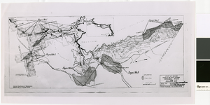
Map of irrigable areas near Boulder Dam, February 20, 1935
Date
1935-02-20
Archival Collection
Description
'Drawn by C.G.C.' 'Carson City, Nevada, Feb. 20, 1935. No. 4.' 'Adapted from Bureau of Reclamation's General map of irrigable areas.'
Image
Topographic map of Las Vegas Rancho, showing location of wells and water lines, Las Vegas, Nev., October 18, 1946
Date
1946-10-18
Archival Collection
Description
'May 1, 1940. Revised Oct. 18, 1946.' 'F-225.' Relief shown by contours. Scale [ca. 1:7,200] 1 in.=600 feet.
Image

Plan of proposed new well pipe and fittings for Las Vegas, Nevada, 1936
Date
1936
Archival Collection
Description
Blueprint. Written on back of map:: 'Purposed [sic] new transmission lines--1936--transits.' Las Vegas Land and Water Company?
Image
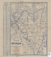
Sketch map of Nevada and the southeastern portion of California, 1906
Date
1906
Description
1907 written in red pencil at top of map. 41 x 29 cm. Relief shown by hachures. Copyright held by George S. Clason. Includes index. "Compliments of A.E. Holt, real estate and mines, Bullfrog Mining Dist., Rhyolite, Nevada." Red star indicates location of A.E. Holt company. Shows railroad routes. Library's copy has "1907" printed with brown crayon in upper margin and has four sets of two holes punched in a vertical line along the right third of the map. Original publisher: Clason Map Co..
Image
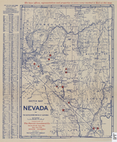
Sketch map of Nevada and the southeastern portion of California, 1906
Date
1906
Description
42 x 29 cm. Relief shown by hachures. Copyright held by George S. Clason. "Compliments of the Patrick Investment Co. ... Denver, Colorado." Includes index. Shows railroad routes. "We have offices, representatives and properties in every camp marked in red on this map." Original publisher: Clason Map Co..
Image
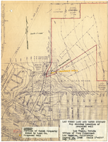
Map showing location of proposed well at Las Vegas, Nevada, August 24, 1948
Date
1948-08-24
Archival Collection
Description
'Office of Vice President, Los Angeles, California.' 'Dwg. F-225.' Relief shown by contours. Hand-drawn red line marks portion of ranch property owned by Land Company. Scale [ca. 1:7,200]. 1 in.=600 feet. Blueline.
Image