Search Results

Map showing plan for water quality management update for wastewater collection systems in the Las Vegas Valley, February 20, 1997
Date
Description
Image
Historical records
Level of Description
Archival Collection
Collection Name: Stardust Resort and Casino Records
Box/Folder: N/A
Archival Component
Historical photographs
Level of Description
Archival Collection
Collection Name: Stardust Resort and Casino Records
Box/Folder: N/A
Archival Component
Southern Nevada Historical Society Records
Identifier
Abstract
The Southern Nevada Historical Society Records document the management and development of the Southern Nevada Historical Society (SNHS) as well as various historical projects in Las Vegas and Southern Nevada that the society sponsored from 1948 to 1983. The records include SNHS correspondence (1951-1978), meeting minutes (1958-1983), and accounting information (1959-1980). It also contains copies of the SNHS Backtrails Newsletter, promotional material for events, membership lists, and research materials for various projects related to the history of southern Nevada and Las Vegas.
Archival Collection
Historical files
Level of Description
Archival Collection
Collection Name: Colorado River Commission of Nevada Reference Library Collection
Box/Folder: N/A
Archival Component
Historic events
Level of Description
Archival Collection
Collection Name: Henderson Public Library Photograph Collection on Henderson, Nevada
Box/Folder: N/A
Archival Component
Historical, undated
Level of Description
Archival Collection
Collection Name: Gilbert Buck Papers
Box/Folder: Box 12
Archival Component
Bryan, J. Phileas Fogg and the Jumping Frog: a collection of wild, weird bets, historical and fictional, Holiday 40(2), 1966 August
Level of Description
Archival Collection
Collection Name: UNLV Libraries Collection of Articles on Gaming and Las Vegas, Nevada Topics
Box/Folder: Box 09
Archival Component
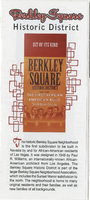
Brochure from Berkley Square Historic District: 1st of Its Kind
Date
Archival Collection
Description
Community brochure produced by City of Las Vegas to commemorate the National Historic District designation.
Text
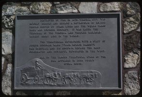
Slide of a historic marker, Virginia City, Nevada, circa 1960s
Date
Archival Collection
Description
Image