Search Results
Music Hall New Years Eve Gala Dinner 1969-1970, menu, 1969
Level of Description
File
Archival Collection
UNLV University Libraries Menu Collection
Archival Component

Savoy Restaurant menu, June 15, 1898
Date
1898-06-15
Archival Collection
Description
Note: Handwritten menu. "Déposé [registered] AD" [printer's monogram] printed under illustration on page 2. Illustration on page 2 shows a woman wearing a toga and sandals, with a raised wine glass and a scepter, riding atop a barrel being pulled by two oversized snails Restaurant: Savoy Restaurant
Text
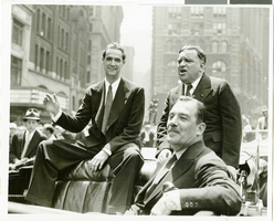
Photograph of Howard Hughes at his parade for Round the World flight, New York City, July 15, 1938
Date
1938-07-15
Archival Collection
Description
Typed onto a piece of paper attached to the image: "Leaving City Hall - 7/15/38. (Daily News)."
Image
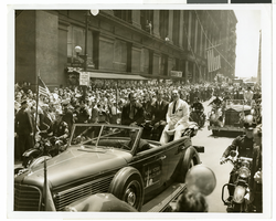
Photograph of Howard Hughes and crew at a parade, New York, July 15, 1938
Date
1938-07-15
Archival Collection
Description
Description printed photograph's accompanying sheet of paper: "Howard Hughes in car receiving the applause of the crowd during his reception in New York. 7-15-38."
Image
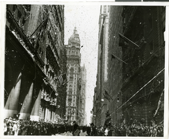
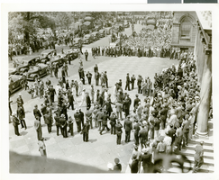
Photograph of a parade procession for Howard Hughes, New York, July 15, 1938
Date
1938-07-15
Archival Collection
Description
A picture of the crowd at a parade celebrating the completion of Howard Hughes' round the world flight. Typed onto a piece of paper attached to the image: "Parade - 7/15/38."
Image

Map of California, Nevada, Utah, Colorado, Arizona & New Mexico, circa 1867
Date
1865 to 1869
Description
39 x 62 cm. Relief shown by hachures and spot heights. Prime meridian: Greenwich and Washington. Hand colored. Shows natural features, populated places, routes of mail steamships, routes of explorers, locations of Indian tribes, railroad routes, and proposed railroad routes. In top margin: No. 80-81. On verso: New Mexico, Arizona, Colorado, Idaho, Dakota (statistics and other information) and The state of California (statistics and other information). Original publisher: G.W. and C.B. Colton.
Image
Photograph of Howard Hughes and his crew at a parade, New York, July 15, 1938
Date
1938-07-15
Archival Collection
Description
The black and white view of Howard Hughes and his crew at a parade after he completed his Round-The-World flight in New York. Handwritten on the back of the image: "B' way parade temporarily blocked by fire engines answering false alarm. 7/15/38."
Image

Photograph of a parade for Howard Hughes, New York City, July 15, 1938
Date
1938-07-15
Archival Collection
Description
Typed onto a piece of paper attached to the image: "Howard Hughes and his crew arriving at the City Hall after their Round-The-World flight. July 1938."
Image
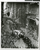
Photograph of a parade for Howard Hughes, New York City, July 15, 1938
Date
1938-07-15
Archival Collection
Description
The black and white view of a parade being held in celebration of Howard Hughes' completion of his Around the World flight in New York City, New York.
Image

Map of California, and territories of Utah, Nevada, Colorado, New Mexico and Arizona, 1864
Date
1864
Description
'Johnson's California, also Utah, Nevada, Colorado, New Mexico, and Arizona, published by A.J. Johnson, New York.' 'Entered according to act of Congress in the year 1864, by A.J. Johnson in the Clerks Office of the District Court of the United States for the southern district of New York.' Atlas page numbers in upper margin: 67-68. Relief shown by hachures. Prime meridian: Greenwich and Washington. Shows natural features, locations of Indian tribes, proposed railroad routes, routes of explorers, trails, county boundaries and populated places. Hand colored. On verso: 'Historical and statistical view of the West India Islands or Columbian Archipelago' (p. 80) and 'Historical and statistical view of Mexico and Central America' (p. 79). Scale [ca. 1:3,484,800]. 1 in. to ca. 55 miles (W 124°--W 102°/N 42°--N 32°).
Text