Search Results
Howard Hughes surrounded by a crowd of people inside of City Hall in New York City, New York, 1938 July 15
Level of Description
File
Archival Collection
Howard Hughes Public Relations Photograph Collection
Archival Component
Howard Hughes surrounded by a crowd of people inside of City Hall in New York City, New York, 1938 July 15
Level of Description
File
Archival Collection
Howard Hughes Public Relations Photograph Collection
Archival Component
The New Fay Easter dinner menu, Sunday, April 7, 1912
Date
1912-04-07
Archival Collection
Description
Restaurant: The New Fay (Virginia, Minn.) Location: Virginia, Minnesota, United States
Text

Photograph of crowds for Howard Hughes outside of City Hall, New York City, July 15, 1938
Date
1938-07-15
Archival Collection
Description
Typed onto a piece of paper attached to the image: "Hughes, Companions Welcomed at City Hall, New York City - In the greatest since Lindbergh's, Howard Hughes and his four gallant companions paraded up Broadway July 15 almost smothered by the accolade of ticker tape which fluttered down upon them from the skyscrapers. This picture was taken as the five record-smashing, Round-The-World fliers posed for photographers in front of City Hall. Credit Line (ACME) 7-15-38."
Image

Map of California, Utah, Nevada, Colorado, New Mexico and Arizona, 1864
Date
1864
Description
'Johnson's California, also Utah, Nevada, Colorado, New Mexico, and Arizona, published by A.J. Johnson, New York.' 'Entered according to Act of Congress in the Year 1864, by A.J. Johnson in the Clerks Office of the District Court of the United States for the Southern District of New York.' Atlas page numbers in upper margin: 66-67. Relief shown by hachures. Prime meridians: Greenwich and Washington, D.C. Shows proposed railroads, locations of Indian tribes, natural features, counties, mines, mail routes, trails and routes of exploring expeditions. On verso: History and statistics of Mexico and Central America and statistics of national finances and the Post Office of the United States, 1860. Scale [ca. 1:3,484,800. 1 in. to ca. 55 miles] (W 123°--W 103°/N 42°--N 32°)
Text
Music Hall New Years Eve Gala Dinner 1969-1970, menu, 1969
Level of Description
File
Archival Collection
UNLV University Libraries Menu Collection
Archival Component

Photograph of Howard Hughes and crew posing for photographs outside of City Hall, New York City, July 15, 1938
Date
1938-07-15
Archival Collection
Description
Typed onto a piece of paper attached to the image: "City Hall steps - 7/15/38. (Daily News)."
Image
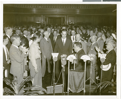
Photograph of Howard Hughes in City Hall, New York City, July 15, 1938
Date
1938-07-15
Archival Collection
Description
Typed onto a piece of paper attached to the image: "Mayor Fiorello Laguardia welcoming Howard Hughes and his four-man crew after flight Around the World. 7/15/38."
Image

Map of California, Nevada, Utah, Colorado, Arizona & New Mexico, circa 1867
Date
1865 to 1869
Description
39 x 62 cm. Relief shown by hachures and spot heights. Prime meridian: Greenwich and Washington. Hand colored. Shows natural features, populated places, routes of mail steamships, routes of explorers, locations of Indian tribes, railroad routes, and proposed railroad routes. In top margin: No. 80-81. On verso: New Mexico, Arizona, Colorado, Idaho, Dakota (statistics and other information) and The state of California (statistics and other information). Original publisher: G.W. and C.B. Colton.
Image

Map of California, and territories of Utah, Nevada, Colorado, New Mexico and Arizona, 1864
Date
1864
Description
'Johnson's California, also Utah, Nevada, Colorado, New Mexico, and Arizona, published by A.J. Johnson, New York.' 'Entered according to act of Congress in the year 1864, by A.J. Johnson in the Clerks Office of the District Court of the United States for the southern district of New York.' Atlas page numbers in upper margin: 67-68. Relief shown by hachures. Prime meridian: Greenwich and Washington. Shows natural features, locations of Indian tribes, proposed railroad routes, routes of explorers, trails, county boundaries and populated places. Hand colored. On verso: 'Historical and statistical view of the West India Islands or Columbian Archipelago' (p. 80) and 'Historical and statistical view of Mexico and Central America' (p. 79). Scale [ca. 1:3,484,800]. 1 in. to ca. 55 miles (W 124°--W 102°/N 42°--N 32°).
Text