
Search the Special Collections and Archives Portal

Search Results

Display    Results Per Page
Displaying results 59721 - 59730 of 147015

Young Audiences New York, Nevada Humanities Photograph Collection

Identifier

PH-00175

Abstract

The Young Audiences New York, Nevada Humanities Photograph Collection (approximately 1970-1979) contains black-and-white photographic prints, slides, and negatives of the Las Vegas, Nevada chapter of the Young Audiences New York arts organization. Images include scenes of concerts, workshops, and chapter outings at public parks. There are images of specific bands within the chapter such as the Brass Quintet, Vocal Quartet, and Woodwind Quintet. Lastly, there are images of celebratory banquets honoring members of the Las Vegas chapter.

Archival Collection

Thunderbird Hotel Records

Identifier

MS-00180

Abstract

The Thunderbird Hotel Records are comprised of material that documents the work of the Las Vegas, Nevada hotel's entertainment department from 1964 to 1973. The records consist of photographs, memorandum, newspaper clippings, and publicity materials.

Archival Collection

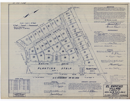
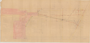
Plat map of El Rancho Village, Clark County, Nevada, July 28, 1942

Date

1942-07-28

Description

Map of housing subdivision outside the Las Vegas city limits. 'Approved this 28 day of July1942, by the City Planning Commission of the City of Las Vegas, County of Clark, Nevada. Approved this 28 day of July 1942, by the County Planning Commission of the County of Clark, State of Nevada.' Blueline print. Oriented with north to the upper right. Embossed with Engineering Certificate seal of Frank D. Rathburn, which states. 'Survey completed August 4, 1942.' 'Book II, page 53' hand printed in lower right corner. Signed by Clark County, Nevada Notary Public and other coumty officials and officials of El Rancho Village. Published by Office of F.D. Rathbun. Scale [ca. 1:600]. 1 inch to 50 feet

Text

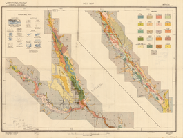
General geologic map of Las Vegas, Pahrump, and Indian Spring Valleys, Clark and Nye Counties, Nevada, 1948

Date

1948

Description

At top of map: 'United States Department of the Interior, Geological Survey. State Engineer of Nevada. Water resources bulletin No. 5, Plate 1.' Relief shown by spot heights. Includes 3 inset maps of wells and springs in the vicinity of Pahrump, Manse Ranch and Indian Springs, Nevada. Scale [ca. 1:126,720. 1 inch to approx. 2 miles] (W 116°--W 115°/N 40°--N 36°). Originally published as plate 1 in Geology and water resources of Las Vegas, Pahrump, and Indian Spring Valleys, Clark and Nye Counties, Nevada by George B. Maxey and C.H. Jameson (1948), which is number 5 of the Water resources bulletin published by the Nevada Office of the State Engineer.

Image

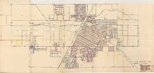
Topographic map of the Las Vegas Valley area, 1959

Date

1959

Description

Scale 1:250,000 ; Transverse Mercator proj. (W 116°--W 114°/N 37°--N 36°) ; 1 map : col. ; 45 x 72 cm ; Relief shown by contours and spot heights. Contour interval 200 feet ; Margin title ; "Compiled in 1955 by photogrammetric methods by U.S. Coast and Geodetic Survey and from Nevada 1:48,000 and 1:62,500, USGS, 1952-54, and Nevada 1:50,000, CE, 1952. Planimetric detail revised by photo-planimetric methods. Horizontal and vertical control by USGS, USC& GS, and CE. Photography field annotated 1954. Road data 1954." ; Shows townships and ranges ; Gives 1955 declination from true north ; Includes location diagram, reliability diagram, and sectionalized township map ; Filing title: Las Vegas, Nevada; Arizona; California ; Interior--Geological Survey

Image

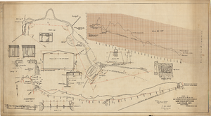
Map showing proposed improvements of Las Vegas Springs, Las Vegas, Nevada, January 26, 1918

Date

1918-01-26

Description

'Exhibit A'. 'Approved Jan. 26, 1918.' Includes discharge figures and plans for improvements to springs for the municipal water system including diagrams of spillway openings, etc. Scale [ca. 1:1200] 1 in.=100 feet -- Scale [ca. 1:120] 1 in.=10 feet -- Scale [ca. 1:240] 1 in.=20 feet -- Scale [ca. 1:24] 1 in.=2 feet -- Scale [ca. 1:2400] 1 in.=200 feet. Vertical scale [ca. 1:48] 1 in.=4 feet -- Scale [ca. 1:12] 1 in.=1 foot.

Image

Map to accompany agreement with Willie T. Stewart, Vernon E. Bunker, Earl Leavitt and William Udell Stewart covering lease of Las Vegas Ranch property at Las Vegas, Nevada, January 31, 1951

Date

1951-01-31

Description

'Las Vegas Land and Water Company, Exhibit A.' 'Office of Vice President, Los Angeles, Califormia. January 31, 1951.' Accompanies document: "N"L.D. 2454 (text of lease of the Las Vegas Ranch) (Box 11 Folder W18-1-12). Scale: 1" = 600'.

Image

Soil map, Nevada, Moapa Valley sheet, 1923

Date

1923

Description

'U.S. Department of Agriculture, Bureau of Chemistry and Soils; C.A. Browne, Acting Chief; Curtis F. Marbut, in charge, Soil Survey.' 'Macy H. Lapham, Inspector, District 5. Soils surveyed by F.O. Youngs, in charge, and E.J. Carpenter.' 'Field Operations, Bureau of Soils, 1923.' 'A, Hoen & Co. Lith. Baltimore, Md.' Shows township and range lines. Scale [1:63,360]. 1 in. = 1 mile (W 114°45´--W 114°18´/N 36°51´--N 36°24´). Library's copy has hand-written notes and has hand-drawn maps and notes on verso.

Image

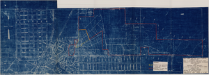
Map of Las Vegas Valley Water District, December 29, 1952

Date

1952-12-29

Description

'Exhibit A.' 'Dec. 29, 1952.' 'I-128.' Scale [ca. 1:3,600]. 1 in.=300 feet. Shows water pipelines, other parts of the water system, and power lines to be removed or relocated when land is sold to the Las Vegas Valley Water District. Shows land to be sold and lists power requirements for water system. Includes township and range lines. Library's copy includes hand-written notations and calculations. Los Angeles & Salt Lake Railroad Company, Office of Vice President?

Image

Map showing various facilities of the Las Vegas Land and Water Company, March 1, 1953

Date

1953-03-01

Description

'Exhibit C.' 'March 1, 1953.' 'I-67.' Scale [ca. 1:7,200] 1 in.=600 feet. Map shows facilities [mainly water-pipes] of Las Vegas Land and Water Company completed and those under construction as of September 1, 1952, and facilities which were commenced after September 1, 1952, and prior to March 1, 1953. Map made as part of the papers for the sale of Las Vegas Land and Water Company facilities to the Las Vegas Valley Water District. Shows township and range lines. Library's copy has hand-written notes in pencil. Las Vegas Land and Water Company?

Image