
Search the Special Collections and Archives Portal

Search Results

Display    Results Per Page
Displaying results 24071 - 24080 of 25260

Cashman, James, Sr., 1884-1962

James "Big Jim" Cashman was born to Benjamin Franklin Cashman and Ella Mary Stovall in Ladue, Missouri on December 16, 1884. Cashman moved to Searchlight, Nevada in 1904 and began working a variety of jobs until he opened an automobile garage in approximately 1910. Cashman later sold automobiles and operated in Searchlight until the mining boom halted around 1920. As a result, Cashman decided to move his business to the growing city of Las Vegas, Nevada. Cashman met his future wife, Leah Barker, in Las Vegas and they married in 1923.

Person

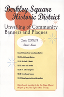
Brochure from the Unveiling of Community Banners and Plaques program, 2013

Date

2013-02-09

Description

Program listing speakers for the community event held to unveil banners and plaques in the Berkley Square Historic District, February 9, 2013.

Text

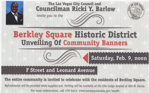
Invitation to Berkley Square Historic District unveiling of Community Banners, February 9, 2013

Date

2013-02-09

Description

Invitation from Councilman Ricki Y. Barlow to the ceremonies to unveil Berkley Square Historic District banners and plaque, February 9, 2013.

Text

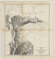
Maps of explorations and surveys for a railroad route from the Mississippi River to the Pacific Ocean, 1855

Date

1855

Description

Map no. 1. From the valley of Green River to the Great Salt Lake -- Map no. 2. From the Great Salt Lake to the Humboldt Mountains -- Map no. 3. From the Humboldt Mountains to the Mud Lakes -- Map no. 4. From the valley of the Mud Lakes to the Pacific Ocean. 'From explorations and surveys made under the direction of the Hon. Jefferson Davis, Secretary of War, by Capt. E.G. Beckwith, 3rd Artillery, E.G. Egloffstein, topographer for the route. 1855.' ''Selmar Siebert's Engraving & Printing Establishment, Washington, D.C.' Published by the War Dept. Scale 1:760,320. 12 miles to 1 in. Relief shown by hachures and spot heights.

Image

Map of California, Utah, Nevada, Colorado, New Mexico and Arizona, 1864

Date

1864

Description

'Johnson's California, with Utah, Nevada, Colorado, New Mexico, and Arizona, published by Johnson and Ward.' 'Entered according to Act of Congress in the Year 1864 by A.J. Johnson in the Clerks Office of the District Court of the United States for the southern district of New York.' Atlas page numbers in upper margin: 66-67. This is probably plate 67 from Johnson's New Illustrated Family Atlas, published in New York by Johnson & Ward in 1864. Shows natural features, locations of Indian tribes, proposed railroad routes, routes of explorers, trails, county boundaries and populated places ; "." ; Relief shown by hachures ; Prime meridians: Greenwich and Washington ; In top margin: 66-67 ; Hand colored ; On verso: Historical and statistical view of Mexico and central America (p. 79) and Historical and statistical view of the United States, 1860 (p. 78) Scale [ca. 1:3,484,800]. 1 in. to ca. 55 miles (W 124°--W 102°/N 42°--N 32°)

Text

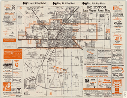
Las Vegas area map, 1960

Date

1960

Description

1960 ed. Scale [ca. 1:47,520. 1 in. equals approx. 0.75 miles.] 1 map : col. ; 41 x 43 cm., folded to 22 x 10 cm. Panel title: Welcome map : greater Las Vegas area and scenic routes to and from there. "1960-61 edition."--Panel. Irregularly-shaped map. Includes list of Las Vegas schools, inset maps of East Las Vegas (Whitney) and Wherry housing area on Nellis Air Force Base and advertisements for Las Vegas businesses. Index, mileages from cities in the United States to Las Vegas and sightseeing information on verso. Library's copy 1 has some art work and some lettering in orange and has "Las Vegas Nevada Chamber of Commerce" stamped in purple on panel. Library's copy 2 has some art work and some lettering in purple and has "Pioneer Title Insurance Co. of Nevada" stamped in black on panel. Nevada State Motel Association?

Text

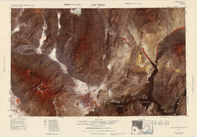
Satellite image map of the Las Vegas Valley, 1981

Date

1981

Description

'1981. Experimental edition 36114-A1-SI-250.' Scale 1:250,000 ; Transverse Mercator proj. (W 116°--W 114°/N 37°--N 36°). Series: Western United States 1:250,000. Western United States 1:250,000 ; NJ 11-12. Filing title: Las Vegas, Nev.; Ariz.; Calif. 'Imagery recorded with Multispectral Scanner (MSS) on NASA Landsat-3.' Includes image coverage diagram. Separate map on verso: Las Vegas / prepared by the U.S. Army Topographic Command ; revised by the U.S. Geological Survey 1969. Ed. 5. Washington, D.C. : Geological Survey, 1976, NJ 11-12 in the series Western United States 1:250,000. United States Geological Survey

Image