Search Results
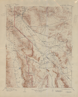
Topographic map of the Furnace Creek quadrangle, Nevada and California, 1947
Date
1947
Description
'E.M. Douglas, geographer. R.H. Chapman, in charge of section. Topography by R.H. Chapman, B.D. Stewart, J.E. Blackburn and D.F.C. Moor. Traingulation by R.H. Chapman and D.F.C. Moor. Surveyed in1905-1906.' 'Edition of Apr. 1910, reprinted 1947.' Scale 1:250,000 ; polyconic proj. (W 117°00´--W 116°00´/N 37°00´--N 36°00´). Relief shown by contours and spot heights. 'North American datum.' 'Contour interval 100 feet.' 'Datum is mean sea level.' Text and illustrations from the Topographic maps of the United States series on verso. Series: The topograhic maps of the United States. United States, Dept. of the Interior, Geological Survey
Text
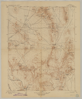
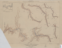
Map of Kawich Quadrangle, Nye County, Nevada, June 1908
Date
1908-06
Description
At upper left corner: 'Department of the Interior, U.S. Geological Survey.' 'E. M. Douglas, geographer; R. G. Chapman, in charge of section; triangulation and topography by R. H. Chapman and B. D. Stewart. Surveyed in 1905.' 'Engraved April 1906 by U.S.G.S.' 'Edition of June 1908, repritned 1929.' 'Polyconic projection. North American datum.' Guide to Topographic Maps of the United States series on map verso. UNLV Special Collections Southern Nevada Mining Map Collection
Text

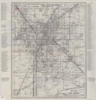
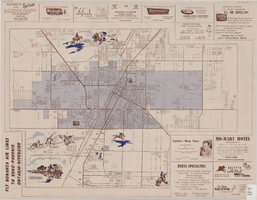
Map of Las Vegas and vicinity, Nevada, circa 1957-1961
Date
1957 to 1961
Description
70 x 68 cm. on sheet 106 x 71 cm. Includes indexes. Includes Nellis Air Force Base, Henderson, and inset maps of Boulder City, Nevada, and Las Vegas's geographical location in the Southwest. "H-654-32" on the lower right-hand corner. Page 2 contains a photograph of the Fremont Street in Downtown Las Vegas, featuring the Golden Nugget Gambling Hall and the Horseshoe Casino. Page 3 outlines local and regional attractions, as well as population information. Original publisher: R. L. Polk.
Image
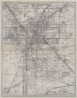
Street map of greater Las Vegas, 1963
Date
1963
Description
55 x 44 cm. Panel title: Front Boy's official 1963-1964 edition street map : detailed guide of North Las Vegas, Las Vegas, Paradise Valley and vicinity. Relief shown by spot heights. Originally folded to: 29 x 12 cm. "Note, revised and recorded 1st - 1961, 2nd - 1962, 3rd 1963, 4th - 1963."On verso: "MAR 1964" stamped in red ink on upper right hand corner. Includes notes and quotations. Includes indexes. Original publisher: Front.
Image

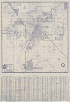
Map of the city of Las Vegas, North Las Vegas, the "Strip", 1963
Date
1963
Description
39 x 36 cm., folded to 28 x 15 cm. Panel title: Welcome map, greater Las Vegas area and scenic routes to and from there. Copyright held by Robert E. Barringer. Includes advertisements for Las Vegas businesses, inset of map of Henderson, Nev., and index. Map of California from San Francisco to Los Angeles to Las Vegas by Beth Bergh, advertisements and index on verso Christmas ed. Greater Las Vegas, 1963-1964 ed. Original publisher: Redwood Publishing Co..
Image
Map of the city of Las Vegas, North Las Vegas, the "Strip", 1957
Date
1957
Description
35 x 50 cm., folded to 22 x 10 cm. Panel title: Inside the greater Las Vegas area. Copyright held by Robert E. Barringer. Map is irregularly shaped. Map of California from San Francisco to Los Angeles to Las Vegas by Beth Bergh, index and advertisements on verso. Includes advertisements for Las Vegas businesses. Stamped on panel of Library's copy: Harrington Insurance Agency. Original publisher: Redwood Publishing Co..
Image
Map of greater Las Vegas, 1960
Date
1960
Description
55 x 44 cm., folded to 30 x 12 cm. Relief shown by spot heights. Includes notes and quotations. Includes indexes. Panel title: Front Boy's official 1962-1963 edition street map: detailed guide of North Las Vegas, Las Vegas, Paradise Valley and vicinity. 1962-1963 ed. Original publisher: Front Boy Service Co..
Image
Street map of Las Vegas and vicinity, 1961
Date
1961
Description
43 x 40 cm., folded to 18 x 9 cm. Panel title: Las Vegas and vicinity map. Includes index. Text with facts about Las Vegas, photographs of Las Vegas and nearby tourist attractions and maps of Henderson, Boulder City and downtown Las Vegas on verso. Library's copy 2 has notes handwritten in black ink. Original publisher: Thomas Bros. Maps, Scale: One inch equals approximately 0.68 mile.
Image

Street map of the city of Las Vegas & vicinity, showing streets, main roads and recreation areas, 1954
Date
1954
Description
7 maps on 3 sheets, 2 leaves ; 21 x 31 cm. or smaller on sheets 22 x 35 cm. folded to 22 x 13 cm. in paper cover. Title from cover. Copyright held by James E. Stringer. 1st ed. Includes maps of North Las Vegas, the Strip and Vegas Heights and Meadow Acres. Includes key to map coordinates. Includes index. "Map of Las Vegas & Vicinity showing streets, main roads, and recreation areas." Original publisher: R.W. Baldwin.
Image