Search Results
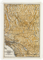
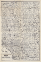
Map of a portion of southern California and southwestern Nevada, circa early 1930s
Date
1930 to 1934
Description
Subtitle: 'Embracing the arid region of Mojave & Colorado deserts including Death Valley.' In lower right-hand corner: '1379.' In lower left-hand corner: 'Burke-Douglas.' Relief shown by shading and spot heights. On verso: Indexes to cities, towns, junctions, resorts, springs, wells, tanks, waterholes, lakes, reservoirs, rivers and creeks, mountains, valleys, mines, canyons, passes, grades, deserts, flats and ranches. Includes mileage tables. 'Prepared by the Route and Map Service of the Automobile Club of Southern California'--Panel. On verso: Map showing roads and points of interest in Death Valley & vicinity. Scale [ca. 1:823,680]. 1 in. to approx. 13 miles (W 119°--W 114°/N 38°--N 33°)
Text
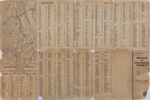
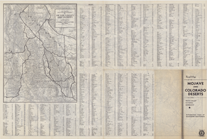
Map of a portion of southern California and southwestern Nevada embracing the arid region of Mojave & Colorado Deserts including Death Valley, circa 1937
Date
1937 (year approximate)
Description
79 x 52 cm. Panel title: Road map of the Mojave and Colorado Deserts including Death Valley National Monument. Index on verso. Relief shown by hachures and spot heights. In lower right-hand corner: Burke Douglas Pflum. "3712."--Lower left-hand corner of copy 1. "C13247."--Lower left-hand corner of copy 2. "1379."--Lower right-hand corner. Originally folded to 28 x 11 cm. On verso: Map showing roads and points of interest in Death Valley and vicinity. Original publisher: The Club.
Image
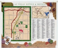
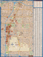
Map of Las Vegas hotels & motels, June 1990
Date
1990-06
Description
Color; 33 x 27 cm. on sheet 46 x 55 cm., folded to 23 x 10 cm. Panel title: Las Vegas area map. Shows locations of hotel and motels in the area of the Strip and Downtown. Also shows locations of country clubs. Includes a separate map of locations of hotels and motels in the surrounding area including North Las Vegas. Includes index. "LVM-75M-6/90."--Verso. Map of locations of golf courses on the verso along with information on points of interest, attractions, general information, tennis, bowling, recreational vehicle parks, and golf.
Image
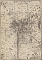
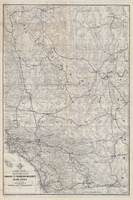
Map of Las Vegas Valley area, 1969
Date
1969
Description
'Featuring Las Vegas ... North Las Vegas ... Paradise Valley.' '1969 edition - revised' -- top of map. Original publisher: Front-Boy Service Co. 1969 ed. Scale [ca. 1:79,200]. 'Copyright - Russell A. Meador, 1968.' Front panel title: 'Front Boy's official 1969 edition street map.' Indexes on map verso. 'Walt Choik, editor, Front Boy Maps' -- back panel.
Text