Search Results
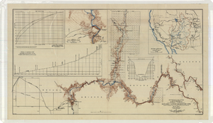
Topographic map of the Boulder Canyon Reservoir site, 1930
Date
1930
Description
Scale [ca. 1:144,000. 1 in. to approx. 12,000 ft.] ; 1 map : col. ; 51 x 91 cm ; Relief shown by contours and spot heights ; "Map no. 23800" ; Includes township and range grid ; Includes two profile diagrams, area and capacity curve diagram, Topography of Black Canyon and vicinity map and Colorado River basin map. Inset maps of Black Canyon and vicinity and Colorado River Basin. Inset charts of Boulder Canyon Reservoir Area and Capacity Curves; and, Profile of Colorado River from Bridge Canyon Dam Site, Arizona to Black Canyon Dam Site, Arizona-Nevada. Bureau of Reclamation.
Image
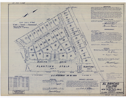
Plat map of El Rancho Village, Clark County, Nevada, July 28, 1942
Date
1942-07-28
Description
Map of housing subdivision outside the Las Vegas city limits. 'Approved this 28 day of July1942, by the City Planning Commission of the City of Las Vegas, County of Clark, Nevada. Approved this 28 day of July 1942, by the County Planning Commission of the County of Clark, State of Nevada.' Blueline print. Oriented with north to the upper right. Embossed with Engineering Certificate seal of Frank D. Rathburn, which states. 'Survey completed August 4, 1942.' 'Book II, page 53' hand printed in lower right corner. Signed by Clark County, Nevada Notary Public and other coumty officials and officials of El Rancho Village. Published by Office of F.D. Rathbun. Scale [ca. 1:600]. 1 inch to 50 feet
Text
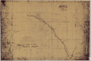
Map showing right of way of toll road constructed by Nevada Rapid Transit Co. in Lincoln County, State of Nevada
Date
1905-08-10
Description
Shows right of way of what now is Interstate 95 through what is now Clark County, Nevada. 'Aug. 10, 1905.' 'Adopted as toll road of Nevada Rapid Transit Company at meeting of Board of Directors of said company Aug. 25th, 1905. Attest W.H. Comstock, secretary, J. Ross Clark, president.' 'Book I, page 3'--Lower right corner. '... No. ... Recorded at ... [signed] J. Ross Clark ... September 1st A.D. 1905 at 40 ... past 8 A.M. to Book of Platts, Pages ... Lincoln Co. Nev. Record ... [signed] Henry Lee ...'--upper right portion of map. Seal of the Nevada Rapid Transit Company in lower left portion of map. Scale [ca. 126,720]. 1 in.=2 miles 1 map. Blueline print.
Image

Geologic map and sections of area along Colorado River between Lake Mead and Davis Dam, Arizona and Nevada, 1963
Date
1963
Description
At top of map: 'United States, Department of Interior, Geological Survey. Professional Paper 374-E, plate 1.' In lower right corner of map: 'Geology mapped by C.R. Longwell.' Relief shown by contours. Includes seven colored cross-sections. Scale 1:125,000 (W 114°50´--W 114°20´/N 36°10´--N 35°10´). Series: Shorter contributions to general geology. Professional paper (Geological Survey (U.S.))374-E. Originally published as plate 1 in: Reconnaissance geology between Lake Mead and Davis Dam, Arizona-Nevada / by Chester R. Longwell, published by the U.S. Government Printing Office in 1963 in the series Shorter contributions to general geology and as Geological Survey professional paper 374-E.
Image

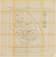
Map of the Las Vegas ground-water basin, Clark, Nye, and Lincoln Counties, Nevada, 1965
Date
1965
Description
At top of map: 'United States Department of the Interior, Geological Survey. Water-supply paper 1780, plate 1.' At bottom of map: 'Base from Army Map Service sheets NJ 11-9, NJ 11-12, and NI 11-3 (1947).' 'Boundary between bedrock and alluvium in Clark County, Nev., compiled by Ben Boyer, E. H. Pampeyan and C. R. Longwell. In Lincoln and Nye Counties, contact determined from aerial photographs.' 'Interior--Geological Survey, Washington, D.C.--1965--W63358.' Includes township and range lines.Relief shown by contours. Thematic map. Scale 1:250,000 (W 116°--W 114°45´/N 37°00´--N 35°30´). Series: Water-supply paper (Washington, D.C.), 1780. Originally published as plate 1 of Available water supply of the Las Vegas ground-water basin, Nevada, by Glenn T. Malmberg, published by the Geological Survey in 1965 as its Water-supply paper 1780.
Image
Map showing estimated average recharge to and discharge from ground-water reservoirs by basins, and hydraulic potential in Clark and Nye counties, Nevada, 1963
Date
1963
Description
'T.E. Eakin, S.L. Schoff, and P. Cohen, 1963.' 'Department of the Interior, United States Geological Survey, TEI-833.' 'Prepared in cooperation with the U.S. Atomic Energy Commission.' Scale 1:500,000 (W 117°30´--W 115°00´/N 38°30´--N 36°30´). Originally published as figure 2 in Regional hydrology of a part of southern Nevada : a reconnaissance / by Thomas E. Eakin, Stuart L. Schoff, and Philip Cohen, published by the U.S. Geological Survey in 1963 as number 833 of the Trace elements investigation report.
Image
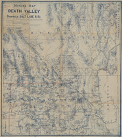
Miners map of Death Valley and the proposed Salt Lake railroads, January 1903
Date
1903-01
Description
Subtitle: 'Including portions of San Bernardino and Inyo Counties, California; Nye and Lincoln Counties, Nevada and Mojave County, Arizona.' 'Compiled and drawn by A. Russell Crowell.' 'May 1902 (Corrected to Jan. 1903.' 'Property of H. Kehoe' written in ink in upper left corner. Scale [ca. 1:506,880]. 1 in. to 8 miles (W 118?--W 114?/N 38?--N 35?). Relief shown by hachures and spot heights. Blueline print. Library's copy has types of minerals found in different areas hand-printed in red and has red lines hand-drawn along county boundaries. G4351.H1 1903 .C76
Image