Search Results
Map of Las Vegas and vicinity, Clark County, Nevada, April 15, 1951
Date
1951-04-15
Description
'2nd issue. 4/15/51.' 'Jack Asher, Reg. C.E. & Land Surveyor, Nev. #305.' Cadastral map..
Image

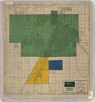
Redevelopment plan map for downtown Las Vegas, Nevada, November 18, 1987
Date
1987-11-18
Description
Scale [ca. 1:12,000. 1 inch equals approx. 1,000 feet]. 1 map ; on sheet 61 x 46 cm. "Nov. 18, 1987." "All land use designations on this map are to be interpreted in conformance with the community profiles component of the Las Vegas General Plan." City of Las Vegas?.
Image
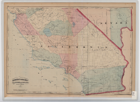
Map of southern California and southern Nevada, 1872
Date
1872
Description
'Entered according to Act of Congress in the year 1872 by Asher & Adams in the office of the Librarian of Congress at Washington.' Scale [ca. 1:1,267,300]. 1 in. to 20 miles (W 124°--W 114°/N 42°--N 32°). Shows natural features, populated places, county boundaries and railroads Prime meridians: Greenwich and Washington. In top margins: 95-96 (south portion). Shows range and township grid. Hand colored. Asher & Adams.
Image
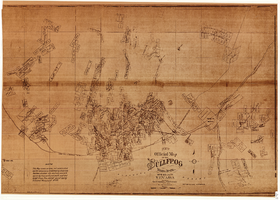
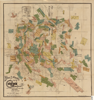
Map of the Bullfrog Mining District, Nye County, Nevada, circa 1905
Date
1901 to 1909
Description
'Compiled by Geo. E. Sherer and W.B. Milliken, miners and surveyors, Bull Frog, Nye Co., Nevada.' 'Photo. Lith. Britton & Rey, S.F.' Scale [ca. 1:16,800. 1 inch to approximately 1,400 feet]. Blueline print.
Image
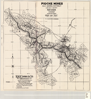
Map of Pioche mines, Ely Mining District, Lincoln County, Nevada, 1909
Date
1909
Description
'A.D. Knowlton, Mining Engineer, Pioche, Nevada; H.H. Snelgrove, Draftsman, Salt Lake City, Utah. Copyright 1909 Rufus K. Cobb.' Includes township and range grid; Includes wagon roads. Published by R.K. Cobb. Photocopy.
Image
Map of the Goldfield Mining District, Nye and Esmeralda Counties, Nevada, 1905
Date
1905
Description
Copyright 1905 by Elmer J. Chute, E.M. Goldfield, Nev. In lower right corner: "Designed and drawn by R.W. Griswold." Includes inset location map; Includes township and range grid. Scale [ca. 1:20, 400. 1 in.=aprrox. 1,700 feet]
Image
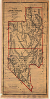
Map of Lincoln and Clark Counties, Nevada, 1908
Date
1908
Description
'Map of Lincoln County, Nevada. Compiled by H.E. Freudenthal from official surveys. Copyright, 1908, by H.E. Freudenthal.' Relief shown by hachures and spot heights. Shows range and township grid. Shows towns, railroads, proposed railroads, wagon roads and springs. Scale [ca. 1:380,160]. 1 in. to approx. 6 miles (W 116°--W 114°/N 39°--N 35°).
Image
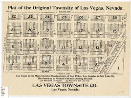
Plat of the original townsite of Las Vegas, Nevada, circa 1905
Date
1905 (year approximate)
Description
'Las Vegas is the main division headquarters of San Pedro, Los Angeles & Salt Lake Ry. The gateway to Nevada's richest mining section. 336 miles from Los Angeles. 444 miles from Salt Lake City.' Second copy available in the J.T. McWilliams manuscript collection.
Image
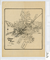
Map of Tonopah Mining District, Nevada, circa 1905
Date
1900 to 1910
Description
Scale [ca.1:12,804. 1 in. to approx. 1,067 ft.] ; 1 map ; on sheet 92 x 106 cm ; Relief shown by hachures ; Title supplied by cataloger ; Probably a preliminary black and white edition of the colored map copyrighted by Bradford and Bradford in 1905 Bradford and Bradford.
Image
Map of Tonopah Mining District, Nye County, Nevada, circa 1903
Date
1899 to 1907
Description
Map showing mining claims in Tonopah Mining District, including areas owned by Tonopah Amalgamated Mining Co.; David Keith's Company of Salt Lake, Utah; Mispah Extension Company; Tonopah Mining Company of Nevada; Gold Hill Mining Co. Relief shown by hachures. Scale [ca. 1:7,200]. 1 in. equals 600 feet. Library's copy has some mines cross-hatched in pencil.
Image