
Search the Special Collections and Archives Portal

Search Results

Display    Results Per Page
Displaying results 320401 - 320410 of 338320

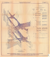
Fence diagram showing lithology of valley-fill deposits and summary of water-bearing properties for valley-fill and bedrock units, Las Vegas Valley, Nevada, 1981 (Open-file report 84-130)

Date

1981

Description

'United States Department of the Interior, Geological Survey. Open-file report 84-130, plate 2.' 'Prepared in cooperation with the Clark County Department of Comprehensive Planning.' 'Geology by R.W. Plume, 1981.' Scale [ca. 1:31,680. 1 in.=approx. .5 miles]. . Series: Open-file report (Geological Survey (U.S.))84-130. Originally published as plate 2 of Ground-water conditions in Las Vegas .Valley, Clark County, Nevada. Part I. Hydrogeologic framework / by Russell W. Plume, published by the U.S. Geological Survey in 1984 as Open-file report 84-130. "Prepared in cooperation with the Clark County Department of Comprehensive Planning."

Text

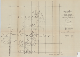
Wagon road from Fort Steele, Wyoming via Rawlins, Union Pacific R.R. to White River Agency, Colo., via cut-off from old road, October, 1878

Date

1878-10

Description

38 x 52 cm. "Topography: Colorado & Utah: U.S. Geolog. Survey Territories, Prof. Hayden in charge and from personal notes & obs--Wyoming: maps, General Land Office & personal notes." "October, 1878." Includes other wagon roads, trails, rivers, ranches, Indian agencies and military reservation. "Drawn by Lieutenant C. A. H. McCauley, 3rd Artillery." "Sen. Ex. Doc. No. 62, 45th Congress 3rd Sess." Original publisher: GPO, Series: Sen. ex. doc no. 62, 45th Congress, 3rd session.

Image

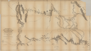
Map based on reconnaissance of the Zuñi, Little Colorado and Colorado Rivers in 1851 by U.S. Corps of Topographical Engineers

Date

1852

Description

Transcribed from the original: 'Made in 1851 under the direction of Col J.J. Abert, Chief of Corps Topographical Engineers, by BVT. Capt. L. Sitgreaves, T.E., assisted by Lieut. J.G. Parke, T.E., and Mr. M.H. Kern. Drawn by R.H. Kern, 1852.' 'Gila River from a reconnaissance by Maj. Emory, Topographical Engrs. Colorado River below Camp Yuma from a reconnaissance by Lt. Derby Topographical Engrs.' Shows Indian villages and forts. Upper right corner partially missing. Scale [ca. 1:650,000]. Scale of 10 miles to one inch.' 'Ackerman Lith.: 379 Broadway, N.Y.'

Image

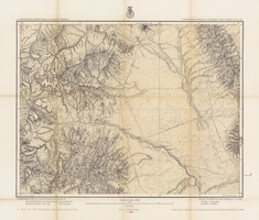
Map of part of south western Colorado, January 10, 1878

Date

1878-01-10

Description

38 x 49 cm. Relief shown by hachures and spot heights. "Atlas sheet no. 61(D)." "Issued Jan. 10th 1878." "Expeditions of 1873, 74, 75 & 76 under the command of 1st. Lieut. Geo. M. Wheeler, Corps of Engineers, U.S. Army." Prime meridians: Washington, D.C. and Greenwich. Includes sectional diagram showing how atlas sheets fit together. "Weyss, Lang & Herman, del." "By order of the honorable the Secretary of War." "Under the direction of Brig. General A. A. Hunphreys, Chief of Engineers, U. S. Army." " J. C. Spiller, Louis Nell, topographical assistants." "Expeditions of 1873, 74, 75 & 76 under the command of 1st. Lieutenant William L. Marshall, Corps of Engineers, U. S. Army, 1st Lieutenant Eric Bergland, Corps of Engineers, U. S. Army, Executive Officers and field astronomers." Original publisher: U.S. Geographical Surveys West of the 100th Meridian, Scale 1 inch to 4 miles or 1:253440.

Image

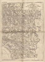
General map showing approximate location of better known springs and wells in the Mohave and adjacent deserts, southeastern California and southwestern Nevada, circa 1908-1909

Date

1905 to 1912

Description

At top of map: 'U.S. Geological Survey, George Otis Smith, Director. Water-supply paper no. 224, pl. 1.' 'Topography compiled from U.S. Geographical Survey atlas sheets,Perris' map of Southern California and other sources.' Relief shown by hachures. Shows township and range grid. Covers the area from Bishop south to the Mexican border, from Long Beach and San Diego to the Arizona border, and the southern part of Nevada, from Beatty and Mesquite south. Scale [ca. 1:1,140,480. 1 in. to approx. 18 miles] (W 118°00´- -W 114°00´/N 37°00´--N 32°32´). Series: Water-supply paper (Washington, D.C.)224. Map is plate 1 from the U.S. Geological Survey Water-supply paper 224.

Image

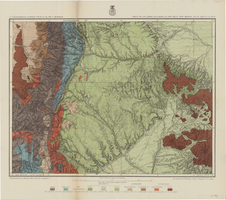
Hydrogeologic map of Nevada Test Site and vicinity, southern Nevada, 1965

Date

1965

Description

At top of map: ' United States Department of the Interior, Geological Survey. Professional paper 712-C, plate 1. Prepared on behald of the U.S. Atomic Energy Commission.' At bottom of map: 'Base from U.S. Geological Survey, Caliente, Death Valley, Goldfield and Las Vegas, 1954. 100,00-foot grid based on Nevada coordinate system, central zone.' 'Hydrogeology by I. J. Winograd, 1965; geology by William Thordarson.' Relief shown by contours and spot heights. Shows township and range lines. Includes diagram of downward and upward cross-flow of water. Includes bibliographical references and index. Contour interval 200 feet. Scale 1:250,000 (W 117°--W 115°/N 38°--N 36°). Series: Professional paper (Geological Survey (U.S.), 712-C. Issued as plate 1 from Hydrogeologic and hydrochemical framework, south-central Great Basin, Nevada-California with special reference to the Nevada Test Site. Prepared on behalf of the U.S. Atomic Energy Commission by Isaac J. Winograd and William Thordarson. Published 1975 by U.S. Govt. Print. Off. in Washington.

Image

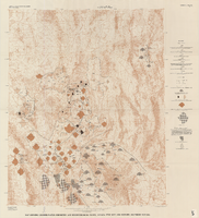
Map showing ground-water chemistry and hydrochemical facies, Nevada Test Site and vicinity, southern Nevada, 1965

Date

1965

Description

'United States Department of the Interior, Geological Survey. Professional paper 712-C, plate 3.' 'Prepared on behalf of the Atomic Energy Commission.' 'Base from U.S. Geological Survey Caliente, Death Valley, Goldfield, and Las Vegas, 1954.' 'Hydrochemistry by I. J. Winograd, 1965.' 'Interior--Geological Survey, Reston, Virginia--1975.' Relief shown by contours. Contour interval 200 feet. Shows township and range lines. Scale 1:250,000 (W 117°--W 115°/N 38°--N 36°). Series: Professional paper (Geological Survey (U.S.))712-C. Issued as plate 3 from U.S. Geological Survey professional paper 712-C, Hydrogeologic and hydrochemical framework, south-central Great Basin, Nevada-California, with special reference to the Nevada Test Site, by I.J. Winograd, and William Thordarson, published in 1975 by the U.S. Geological Survey.

Image

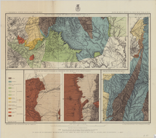
Map of parts of southern Colorado and northern New Mexico, atlas sheet no. 70(A), 1877

Date

1877-05-07

Description

37 x 50 cm. Prime meridian: Washington, D.C. Relief shown by hachures and spot heights. "Issued May 7th, 1877. 2nd ed., June 30th, 1881." "Atlas sheet no. 77(B)." "Expeditions of 1871 & 1786 under the command of 1st. Lieut. Geo. M. Wheeler, Corps of Engineers, U.S. Army." "Weyss, Herman & Lang, del." Probably originally published as part of the geological atlas which is an appendix to the Surveys' Report upon United States geographical surveys west of the one hundredth meridian. Geological map. "Prof. John J. Stevenson, geological assistant." Original publisher: U.S. Geographical Surveys West of the 100th Meridian, Scale: 1 inch to 4 miles or 1: 253440.

Image

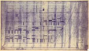
Plat of original townsite of Las Vegas, Clark County, Nevada, November 25, 1927

Date

1927-11-25

Description

Subtitle: 'On N 1/2 of SW 1/4 section 27, T 20 S, R 61 E, M.D. Mer. showing cast iron water mains. Including location and distances of valves, fire hydrants, house connections, etc. Constructed by Las Vegas Land &Water Company. Construction completed Nov. 25-1927. Cast iron pipe system throughout made at Provo, Utah by Pacific States Cast Iron Pipe Company. R.N. Clark, Construction Engineer. Map and survey made by J.T. McWilliams, C.E., Las Vegas, Nev.' Map shows ownership of some parcels of land. Scale [ca. 1:960]. 1 inch to 80 feet. Blueline print. Plat map.

Image

Map of part of North Central New Mexico atlas sheets 69(B), 69(D), 77(B) and 78(A), June 30, 1881

Date

1881-06-30

Description

39 x 52 cm. Relief shown by hachures and spot heights "Issued June 30, 1881." "Expeditions of 1873, 1878 and 1879 under the command of 1st. Lieut. Geo. M. Wheeler, Corps of Engineers U.S. Army." Geological map Probably originally published as part of the geological atlas which is an appendix to the Surveys' Report upon United States geographical surveys west of the one hundredth meridian. "Prof. John J. Stevenson, geological assistant." "By order of the honorable the Secretary of War under the direction of Brig. General A. A. Hunphreys, Chief of Engineers, U. S. Army." Original publisher: U.S. Geographical Surveys West of the 100th Meridian, Scale: 1 inch to 4 miles or 1: 253440.

Image