Search Results
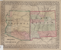
Map of Arizona and New Mexico, 1867
Date
1867
Description
26 x 32 cm. Relief shown by hachures. "Entered according to act of Congress in the year 1867 by S. Augustus Mitchell in the Clerks Office of the District Court for the Eastern District of Pennsylvania." Includes decorative border of grape vines. Shows Tucson as capital of Arizona; shows various trails including Cook's Wagon Route, Marcy's Route, and Kearney's Route. Written in pencil in lower right corner: 135. Original publisher: S.A. Mitchell.
Image
Show rehearsal, New York City, New York, 1964
Level of Description
File
Archival Collection
Minsky's Burlesque Records
To request this item in person:
Collection Number: MS-00290
Collection Name: Minsky's Burlesque Records
Box/Folder: Box 1 (Restrictions apply)
Collection Name: Minsky's Burlesque Records
Box/Folder: Box 1 (Restrictions apply)
Archival Component
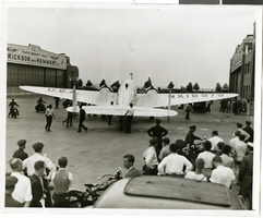
Photograph of Howard Hughes in New York, July 1938
Date
1938-07
Archival Collection
Description
A view of crowds watching Howard Hughes arrive at Floyd Bennett Field in New York.
Image
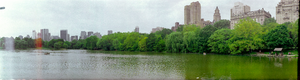
Central Park, New York City, New York: panoramic photographs
Date
1981-05-31
Archival Collection
Description
From the Bob Paluzzi Panoramic Photographs
Image

Photograph of Howard Hughes in New York, July 1938
Date
1938-07
Archival Collection
Description
A view of Howard Hughes sitting with two unidentified men in the back of a car, likely being driven to a New York hotel, after landing the Lockheed 14 at Floyd Bennett Field.
Image
Report: "Study of Betting on Sports in New York City" by the Fund for the City of New York Quayle Survey
Level of Description
File
Archival Collection
Eugene Martin Christiansen Papers
To request this item in person:
Collection Number: MS-00561
Collection Name: Eugene Martin Christiansen Papers
Box/Folder: Box 168
Collection Name: Eugene Martin Christiansen Papers
Box/Folder: Box 168
Archival Component
"The New York City Office of the Comptroller Discussion Materials Regarding New York City OTB", 2007
Level of Description
File
Archival Collection
Eugene Martin Christiansen Papers
To request this item in person:
Collection Number: MS-00561
Collection Name: Eugene Martin Christiansen Papers
Box/Folder: Box 069
Collection Name: Eugene Martin Christiansen Papers
Box/Folder: Box 069
Archival Component


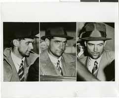
Photograph of Howard Hughes in New York, July 1938
Date
1938-07-14
Archival Collection
Description
Multiple, close up views of Howard Hughes in the back of an automobile in New York. Typed onto a piece of paper attached to the image: "Howard Hughes at Floyd Bennett Airport being interviewed after his record-breaking flight around the world. 7/14/38."
Image