Search the Special Collections and Archives Portal
Search Results
Slide images of Harrah's Reno, Harrah's Lake Tahoe, and Harrah's Marina in Atlantic City, New Jersey, undated
Level of Description
File
Archival Collection
Harrah’s Entertainment Corporate Archives
To request this item in person:
Collection Number: MS-00460
Collection Name: Harrah’s Entertainment Corporate Archives
Box/Folder: Box 046
Collection Name: Harrah’s Entertainment Corporate Archives
Box/Folder: Box 046
Archival Component
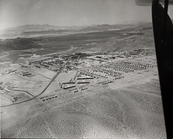
Photograph of Boulder City, Nevada, March 28, 1937
Date
1937-03-28
Archival Collection
Description
The grayscale, aerial view of Boulder City, Nevada. The prominent road of Nevada Way can be seen passing through the little town with the great reservoir of Lake Mead residing in the background. Bits of the actual plane from which the photo was taken can be seen alongside the right border of the image.
Image
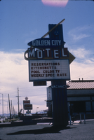
Slide of the Golden City Motel, Nevada, 1986
Date
1986
Archival Collection
Description
Sign advertising the Golden City Motel located on the sign of the Boulder Highway in Nevada. Transcribed onto the sign: "Golden City Motel; Reservations, Kitchenetts, Pool, Color TV, Weekly Spec. Rate." Site Name: Golden City Motel (Las Vegas, Nev.)
Image
"Fink's NYRA Proposal as It Would Affect OTB" for the New York City Off-Track Betting Corporation, 1981
Level of Description
File
Archival Collection
Eugene Martin Christiansen Papers
To request this item in person:
Collection Number: MS-00561
Collection Name: Eugene Martin Christiansen Papers
Box/Folder: Box 045
Collection Name: Eugene Martin Christiansen Papers
Box/Folder: Box 045
Archival Component
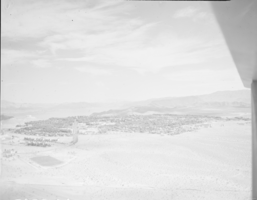
Film transparency of Boulder City, Nevada, circa 1931-1936
Date
1931 to 1936
Archival Collection
Description
An image showing an aerial view of Boulder City. The outlines of the small city are distinctively marked by the stark contrast between the city's greenery and the surrounding desert. Bits of the airplane from which the image itself was taken can be seen in the upper right corner of the photograph.
Image
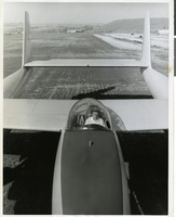
Photograph of Howard Hughes sitting in the cockpit of the XF-11 preparing for his first test flight in Culver City, California July 7, 1947
Date
1947
Archival Collection
Description
Transcribed from press release attached to back of photo: "NEW PHOTO PLANE TEST-FLOWN CULVER CITY, California, July 7 -- Howard Hughes, who designed and built the new FX-11 reconnaissance plane in conjunction with Air Materiel Command engineers, sits in the pilot's bubble-glass canopy preparing for the first test flight. One of the world's fastest long-range photo planes, the XF-11 can attain a speed of more than 400 miles per hour, Army officials said. It is powered by two 3000-horsepower radial engines with eight-bladed contra-rotating propellers. Outstanding features include a full-span flap, unique eight-camera layout, and exceptionally fast take-off." Transcribed from photo sleeve: "Howard Hughes sits in the cockpit of the XF-11, a reconnaissance plane that Hughes built and designed in conjunction with Air Materiel Command engineers. Hughes is preparing for his first test flight in Culver City, California July 7, 1947.
Image

Photograph of Howard Hughes in New York, July 1938
Date
1938-07-14
Archival Collection
Description
Multiple, close up views of Howard Hughes in the back of an automobile in New York. Typed onto a piece of paper attached to the image: "Howard Hughes at Floyd Bennett Airport being interviewed after his record-breaking flight around the world. 7/14/38."
Image

Film transparency of Boulder City, Nevada, circa 1931-1936
Date
1931 to 1936
Archival Collection
Description
An image showing an aerial view of Boulder City. The outlines of the small city are distinctively marked by the stark contrast between the city's greenery and the surrounding desert. Note: Bits of the airplane from which the image itself was taken can be seen in the upper right corner of the photograph.
Image
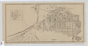
Cadastral map of Boulder City, Nevada, 1940
Date
1905-04-23
Description
A. M. S. Jan. 1940 in the lower left-hand corner. 1 map ; 61 x 30 cm. Cadastral map. "No. 40-1" in the lower right-hand corner. Shows block and lot numbers, buildings, water supply and sewage system, leased areas.
Image
Las Vegas City Commission Minutes, December 8, 1959 to February 17, 1960
Date
1959-12-08 to 1960-02-17
Archival Collection
Description
Bound volume of Las Vegas City Commission Minutes, December 8, 1959 to February 17, 1960
Text
Pagination
Refine my results
Content Type
Creator or Contributor
Subject
Archival Collection
Digital Project
Resource Type
Year
Material Type
Place
Language
Records Classification
