Search Results
Speech before the American Transportation Assocation Annual Luncheon, New York City, 1980 February 28
Level of Description
File
Archival Collection
Howard Cannon Papers
To request this item in person:
Collection Number: MS-00002
Collection Name: Howard Cannon Papers
Box/Folder: Box 17 (Speeches)
Collection Name: Howard Cannon Papers
Box/Folder: Box 17 (Speeches)
Archival Component
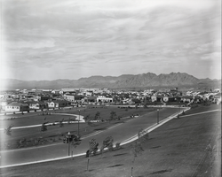
Photograph of Boulder City, Nevada, September 20, 1933
Date
1933-09-20
Archival Collection
Description
The grayscale view from an unidentified park of Boulder City, Nevada.
Image
Menu for the Surrey Sportsman's Club, The Secretary's Feast, City of New York Restaurant, 1899 July 05
Level of Description
Item
Archival Collection
Bohn-Bettoni Menu Collection
To request this item in person:
Collection Number: MS-00793
Collection Name: Bohn-Bettoni Menu Collection
Box/Folder: Box 06
Collection Name: Bohn-Bettoni Menu Collection
Box/Folder: Box 06
Archival Component

Photograph of the Lockheed 14 aircraft at Floyd Bennett Field, New York, July 10, 1938
Date
1938-07-10
Archival Collection
Description
The black and white view of the Lockheed 14 aircraft being surrounded by people at Floyd Bennett Field in New York.
Image
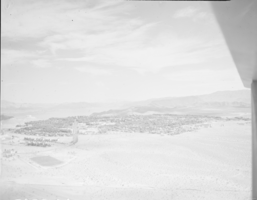
Film transparency of Boulder City, Nevada, circa 1931-1936
Date
1931 to 1936
Archival Collection
Description
An image showing an aerial view of Boulder City. The outlines of the small city are distinctively marked by the stark contrast between the city's greenery and the surrounding desert. Bits of the airplane from which the image itself was taken can be seen in the upper right corner of the photograph.
Image
Senate Committee - Banking Committee - New York City Financial Crisis, 1978 May to 1978 August
Level of Description
File
Archival Collection
Howard Cannon Papers
To request this item in person:
Collection Number: MS-00002
Collection Name: Howard Cannon Papers
Box/Folder: Box 06 (95th Session)
Collection Name: Howard Cannon Papers
Box/Folder: Box 06 (95th Session)
Archival Component

Map of California and territories of New Mexico and Utah, circa 1861
Date
1856 to 1866
Description
40 x 60 cm. Relief shown by hachures and spot heights. Prime meridians: Greenwich and Washington. Atlas plate numbers 54 and 55 in the upper corners. Shows forts, trails, exploration routes, drainage, mail steamship routes, physical features, Indian tribes, and historic sites. The geographic region of Southwest is referred to as the New Southwest. Original publisher: Johnson .
Image
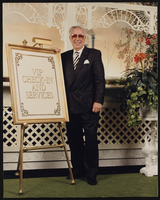
Unidentified casino executive standing next to VIP check-in and services sign at the Showboat Casino, Atlantic City, New Jersey: photographic print
Date
1986
Archival Collection
Description
From the Showboat Atlantic City Photograph Collection (PH-00329).
Image
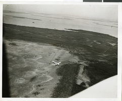
Photograph of the landing of Howard Hughes' Lockheed 14 aircraft, New York, July 14, 1938
Date
1938-07-14
Archival Collection
Description
The black and white, aerial view of Howard Hughes' Lockheed 14 aircraft preparing for its final landing on its Round the World flight in Floyd Bennett Field, New York. Typed onto a piece of paper attached to the image: "Aerial New of landing, 7-14-38. (Daily News.)" Typed onto a second piece of paper attached to the image: "Howard Hughes plane from a welcoming plane as the Round the World flight ended at Floyd Bennett Field."
Image