Search Results
Vassili Sulich and dance partner, New York City, New York, approximately 1960-1969
Level of Description
File
Archival Collection
Vassili Sulich Photographs
To request this item in person:
Collection Number: PH-00353
Collection Name: Vassili Sulich Photographs
Box/Folder: Folder 13
Collection Name: Vassili Sulich Photographs
Box/Folder: Folder 13
Archival Component
Howard Hughes and crew in parade up Broadway after record-breaking around-the-world flight New York, New York, 1938 July 15
Level of Description
File
Archival Collection
Howard Hughes Public Relations Photograph Collection
To request this item in person:
Collection Number: PH-00373
Collection Name: Howard Hughes Public Relations Photograph Collection
Box/Folder: Folder 10
Collection Name: Howard Hughes Public Relations Photograph Collection
Box/Folder: Folder 10
Archival Component
Central Park, New York City, New York: panoramic photograph, 1981 May 31
Level of Description
Item
Archival Collection
Bob Paluzzi Panoramic Photographs
To request this item in person:
Collection Number: PH-00414
Collection Name: Bob Paluzzi Panoramic Photographs
Box/Folder: Box 07, Digital File 00
Collection Name: Bob Paluzzi Panoramic Photographs
Box/Folder: Box 07, Digital File 00
Archival Component

Map of California, with territories of Utah, Nevada, Colorado, New Mexico, and Arizona, 1864
Date
1864
Description
40 x 62 cm. Relief shown by hachures. Prime meridians: Greenwich and Washington. Page numbers at top: 58-59. "Entered according to act of Congress in the year 1864 by A. J. Johnson in the Clerk's Office of the District Court of the United States for the Southern District of New York." Original publisher: Johnson and Ward.
Image

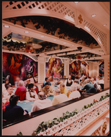
Restaurant in the Showboat Casino, Atlantic City, New Jersey: photographic print
Date
1986
Archival Collection
Description
From the Showboat Atlantic City Photograph Collection (PH-00329).
Image
Gamblers in the Showboat Casino, Atlantic City, New Jersey: photographic print
Date
1986
Archival Collection
Description
From the Showboat Atlantic City Photograph Collection (PH-00329).
Image

Gamblers in the Showboat Casino, Atlantic City, New Jersey: photographic print
Date
1986
Archival Collection
Description
From the Showboat Atlantic City Photograph Collection (PH-00329).
Image
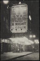
The marquee of the 44th Street Theatre, New York City: photographic print
Date
1890 (year approximate) to 1980 (year approximate)
Archival Collection
Description
The marquee of the 44th Street Theatre, New York City. Grace Hayes' name is on the marquee for the show "A Night in Spain."
Image

Map of California, Utah, Nevada, Colorado, New Mexico and Arizona, 1864
Date
1864
Description
'Johnson's California, with Utah, Nevada, Colorado, New Mexico, and Arizona, published by Johnson and Ward.' 'Entered according to Act of Congress in the Year 1864 by A.J. Johnson in the Clerks Office of the District Court of the United States for the southern district of New York.' Atlas page numbers in upper margin: 66-67. This is probably plate 67 from Johnson's New Illustrated Family Atlas, published in New York by Johnson & Ward in 1864. Shows natural features, locations of Indian tribes, proposed railroad routes, routes of explorers, trails, county boundaries and populated places ; "." ; Relief shown by hachures ; Prime meridians: Greenwich and Washington ; In top margin: 66-67 ; Hand colored ; On verso: Historical and statistical view of Mexico and central America (p. 79) and Historical and statistical view of the United States, 1860 (p. 78) Scale [ca. 1:3,484,800]. 1 in. to ca. 55 miles (W 124°--W 102°/N 42°--N 32°)
Text