Search Results

Slide of aerial view of University of Nevada, Las Vegas campus, circa 1963-1966
Date
1963 to 1966
Archival Collection
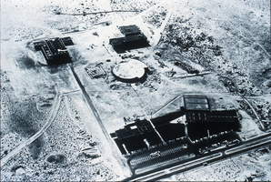
Description
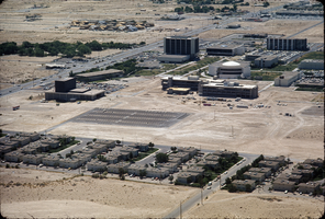
Partial aerial view, looking west, of University of Nevada, Las Vegas (then Nevada Southern University) campus. The Gymnasium is at the left, the library building is in the center and the Fong Geoscience Building is at the right (all with deep shadows to the east). A small parking lot is next to the library.
Image
Slide of aerial view of University of Nevada, Las Vegas campus, circa 1963-1966
Date
1963 to 1966
Archival Collection
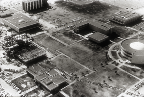
Description
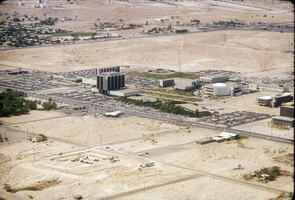
Aerial view, looking west, of University of Nevada, Las Vegas (then Nevada Southern University) campus. Maude Frazier Hall and Archie Grant Hall (at an angle) are seen in the foreground. The round library building is in the center behind them. The Gymnasium is at the upper left, and the Fong Geoscience Building is at the upper center.
Image
Slide of aerial view of University of Nevada, Las Vegas campus, circa 1971-1972
Date
1970 to 1972
Archival Collection
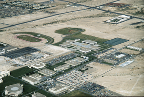
Description
Partial aerial view, looking southwest of the University of Nevada, Las Vegas campus. Construction on the Flora Dungan Humanities Building is seen at the left center.
Image
Slide of aerial view of University of Nevada, Las Vegas campus, circa 1975-1976
Date
1974 to 1976
Archival Collection
Description
Partial aerial view, looking west, of University of Nevada, Las Vegas campus, showing construction on the Juanita Greer White Life Sciences building (gray building near center right of photo).
Image
Slide of aerial view of University of Nevada, Las Vegas campus, circa 1975-1976
Date
1975 to 1976
Archival Collection
Description
Aerial view, looking northwest, of the University of Nevada, Las Vegas campus, showing construction on Artemus W. Ham Concert Hall. The Landmark Hotel is seen in the north (center right of the photo).
Image

Slide of aerial view of University of Nevada, Las Vegas campus, circa 1972-1975
Date
1972 to 1975
Archival Collection
Description
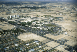
Aerial view, looking southwest, of the University of Nevada, Las Vegas campus. Maryland Parkway is in the center of the photo.
Image
Slide of aerial view of University of Nevada, Las Vegas campus, circa 1972-1975
Date
1972 to 1975
Archival Collection
Description
Partial aerial view, looking southwest, of the University of Nevada, Las Vegas campus. Maryland Parkway is in the center of the photo.
Image
Slide of aerial view of University of Nevada, Las Vegas campus, circa 1975
Date
1975 to 1976
Archival Collection
Description
Aerial view, looking northwest, of the University of Nevada, Las Vegas campus, showing construction on the Artemus W. Ham Concert Hall.
Image
Slide of aerial view of University of Nevada, Las Vegas campus, circa 1972-1975
Date
1972 to 1975
Archival Collection
Description
Partial aerial view, looking southeast, of the University of Nevada, Las Vegas campus. Maryland Parkway is seen at the left of the photo.
Image
Postcard of hotels on the Las Vegas Strip, early-mid 1960s
Date
1960 to 1966
Archival Collection
Description
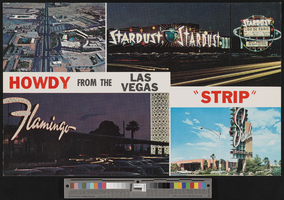
Oversized postcard with four photographs taken in Las Vegas, Nevada: a daytime aerial view of a portion of the Las Vegas Strip; the exteriors of the Stardust and Flamingo Hotels at night; and the exterior of the Sands Hotel. Caption: "Howdy from the Las Vegas 'Strip'." Site Name: Flamingo Hotel and Casino (Las Vegas, Nev.); Stardust Resort and Casino; Sands Hotel and Casino
Image