
Search the Special Collections and Archives Portal

Search Results

Display    Results Per Page
Displaying results 601 - 610 of 145236

Wilbur and Toni Clark at a formal dinner at the Hotel Astor in New York City, New York, 1958

Level of Description

File

Archival Collection

Toni and Wilbur Clark Photographs
To request this item in person:
Collection Number: PH-00302
Collection Name: Toni and Wilbur Clark Photographs
Box/Folder: Folder 10

Archival Component

Restaurant in the Showboat Casino, Atlantic City, New Jersey, 1986

Level of Description

Item

Archival Collection

Showboat Atlantic City Photograph Collection
To request this item in person:
Collection Number: PH-00329
Collection Name: Showboat Atlantic City Photograph Collection
Box/Folder: Folder 01

Archival Component

Gamblers in the Showboat Casino, Atlantic City, New Jersey, 1986

Level of Description

Item

Archival Collection

Showboat Atlantic City Photograph Collection
To request this item in person:
Collection Number: PH-00329
Collection Name: Showboat Atlantic City Photograph Collection
Box/Folder: Folder 01

Archival Component

Transcript of interview with Mary E. Habbart by Pamela Larkins, July 15, 1975

Date

1975-07-15

Description

On July 15, 1975, Pamela Larkins interviewed Mary E. Habbart (born 1897 in Boothwyn, Pennsylvania) in her home in Las Vegas, Nevada. The two discuss Habbart’s personal family history and her family’s reasons for moving to Las Vegas. Habbart also describes social and economic changes to Las Vegas and her local dairy farm.

Text

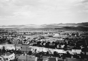
Film transparency of Boulder City, Nevada, December 15, 1933-June, 1934

Date

1933 to 1934

Archival Collection

Description

Panoramic view of houses from the water tank in Boulder City. This photo was taken between December 15, 1933 and June, 1934. Buildings that can be seen include City Hall (left), the Boulder Theater building (center), the Boulder Dam Hotel (right), and the Terminal Building with the Boulder Cafe (right).

Image

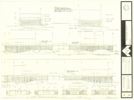
Architectural drawing of concert hall and drama theater, University of Nevada, Las Vegas, exterior elevations, November 5, 1969

Date

1969-11-05

Description

Exterior elevations for the concert hall and drama theater on the University of Nevada, Las Vegas campus, including a connecting courtyard. These buildings would become the Artemus W. Ham Concert Hall and the Judy Bayley Theatre. Sheet 6 of 35. "Drawn by G.T. Checked by K.D. Job number 6828. Scale 1/16" = 1'-0". Date Nov. 5, 1969"
Site Name: University of Nevada, Las Vegas
Address: 4505 S. Maryland Parkway

Image

Map of California, Nevada, Utah, Colorado, Arizona & New Mexico, circa 1867

Date

1865 to 1869

Description

39 x 62 cm. Relief shown by hachures and spot heights. Prime meridian: Greenwich and Washington. Hand colored. Shows natural features, populated places, routes of mail steamships, routes of explorers, locations of Indian tribes, railroad routes, and proposed railroad routes. In top margin: No. 80-81. On verso: New Mexico, Arizona, Colorado, Idaho, Dakota (statistics and other information) and The state of California (statistics and other information). Original publisher: G.W. and C.B. Colton.

Image

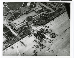
Aerial photograph of the Floyd Bennett Airport, New York, July 14, 1938

Date

1938-07-14

Description

Aerial view of the crowd greeting Howard Hughes and crew at the Floyd Bennett Airport in New York after completion of the around-the-world flight.

Image

The New Superstar Commune: Las Vegas, Cavalier, 1975 July 24

Level of Description

Item

Archival Collection

Arnold Shaw Papers
To request this item in person:
Collection Number: MS-00432
Collection Name: Arnold Shaw Papers
Box/Folder: Box 14

Archival Component

Map of California, and territories of Utah, Nevada, Colorado, New Mexico and Arizona, 1864

Date

1864

Description

'Johnson's California, also Utah, Nevada, Colorado, New Mexico, and Arizona, published by A.J. Johnson, New York.' 'Entered according to act of Congress in the year 1864, by A.J. Johnson in the Clerks Office of the District Court of the United States for the southern district of New York.' Atlas page numbers in upper margin: 67-68. Relief shown by hachures. Prime meridian: Greenwich and Washington. Shows natural features, locations of Indian tribes, proposed railroad routes, routes of explorers, trails, county boundaries and populated places. Hand colored. On verso: 'Historical and statistical view of the West India Islands or Columbian Archipelago' (p. 80) and 'Historical and statistical view of Mexico and Central America' (p. 79). Scale [ca. 1:3,484,800]. 1 in. to ca. 55 miles (W 124°--W 102°/N 42°--N 32°).

Text