Search the Special Collections and Archives Portal
Search Results
#03693: Artemus W. Ham Concert Hall, 1979 November 15
Level of Description
File
Archival Collection
University of Nevada, Las Vegas Creative Services Records (1970s)
To request this item in person:
Collection Number: PH-00388-01
Collection Name: University of Nevada, Las Vegas Creative Services Records (1970s)
Box/Folder: N/A
Collection Name: University of Nevada, Las Vegas Creative Services Records (1970s)
Box/Folder: N/A
Archival Component

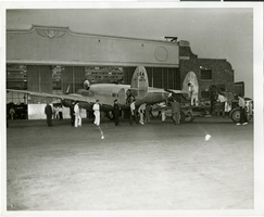
Photograph of people surrounding the Lockheed 14 aircraft, New York, July 9, 1938
Date
1938-07-09
Archival Collection
Description
The black and white view of unidentified people surrounding the Lockheed 14 aircraft. Typed on a piece of paper attached to the image: "Rolling Howard Hughes' plane out of hangar at Floyd Bennett Field, with Lt. Thomas Thurlow, one of the navigators, calibrating the compass. 7/9/38."
Image

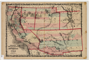
Map of California and territories of New Mexico and Utah, circa 1861
Date
1859 to 1862
Description
'Compiled, drawn, and engraved under the supervision of J.H. Colton and A.J. Johnson.' Relief shown by hachures and spot heights. Scale [ca. 1:3,041,280]. 1 in. to approx. 48 miles (W 124°--W 103°/N 42°--N 31°). Hand colored
Prime meridians: Greenwich and Washington
Plates 54 & 55 removed from Johnson's New illustrated family atlas of the world, with descriptions geographical, statistical and historical ... New York, 1862
Title page of atlas.
Prime meridians: Greenwich and Washington
Plates 54 & 55 removed from Johnson's New illustrated family atlas of the world, with descriptions geographical, statistical and historical ... New York, 1862
Title page of atlas.
Image
"Las Vegas Town Hall, Beltway", 1996 April 15
Level of Description
Item
Archival Collection
UNLV TV Audiovisual Collection
To request this item in person:
Collection Number: UA-00098
Collection Name: UNLV TV Audiovisual Collection
Box/Folder: Box 11
Collection Name: UNLV TV Audiovisual Collection
Box/Folder: Box 11
Archival Component
New York Mine, Silver City, Nevada
Level of Description
File
Archival Collection
Mary Griffith Toleno Photograph Collection
To request this item in person:
Collection Number: PH-00021
Collection Name: Mary Griffith Toleno Photograph Collection
Box/Folder: N/A
Collection Name: Mary Griffith Toleno Photograph Collection
Box/Folder: N/A
Archival Component
North Las Vegas and City Hall construction, 1940s-1960s
Level of Description
File
Archival Collection
North Las Vegas Library District Collection on Nevada
To request this item in person:
Collection Number: MS-00651
Collection Name: North Las Vegas Library District Collection on Nevada
Box/Folder: Box 12
Collection Name: North Las Vegas Library District Collection on Nevada
Box/Folder: Box 12
Archival Component
Howard Hughes boarding airliner for Washington, D.C., 1938 July 15
Level of Description
File
Archival Collection
Howard Hughes Public Relations Photograph Collection
To request this item in person:
Collection Number: PH-00373
Collection Name: Howard Hughes Public Relations Photograph Collection
Box/Folder: Folder 13
Collection Name: Howard Hughes Public Relations Photograph Collection
Box/Folder: Folder 13
Archival Component

Photograph of Howard Hughes at Floyd Bennett Airfield, New York, July 14, 1938
Date
1938-07-14
Archival Collection
Description
The view of a crowd of people watch Howard Hughes walk through Floyd Bennett Airfield in New York. Description printed on photograph's accompanying sheet of paper: "A scene at Floyd Bennett Field as Howard Hughes and his crew landed after completing a round the world hop. 7-14-38 (Press Association)."
Image

Trial hearings at City Hall in Las Vegas, Nevada: photographic slide
Date
1979-05
Archival Collection
Description
From the Sister Klaryta Antoszewska Photograph Collection (PH-00352). Hearings for individuals arrested at the Lenten Desert Experience.
Image
Wilbur Square Park in Boulder City, Nevada, approximately 1937-1938
Level of Description
File
Archival Collection
L. F. Manis Photograph Collection
To request this item in person:
Collection Number: PH-00100
Collection Name: L. F. Manis Photograph Collection
Box/Folder: Folder 80
Collection Name: L. F. Manis Photograph Collection
Box/Folder: Folder 80
Archival Component
Pagination
Refine my results
Content Type
Creator or Contributor
Subject
Archival Collection
Digital Project
Resource Type
Year
Material Type
Place
Language
Records Classification
