Search Results
Attorneys and statutory agents - appointment in New York City, 1911-1960
Level of Description
File
Archival Collection
Union Pacific Railroad Collection
Archival Component
Lockheed 14 aircraft over New York City, 1938 July
Level of Description
File
Archival Collection
Howard Hughes Public Relations Photograph Collection
Archival Component
Lockheed 14 aircraft over New York City, 1938 July
Level of Description
File
Archival Collection
Howard Hughes Public Relations Photograph Collection
Archival Component
Garden Pier, Atlantic City, New Jersey: photograph, 1936 to 1937
Level of Description
Item
Archival Collection
Larry Fotine Music collection
Archival Component
Steel Pier marquee, Atlantic City, New Jersey: photograph, 1951
Level of Description
Item
Archival Collection
Larry Fotine Music collection
Archival Component
Steel Pier marquee, Atlantic City, New Jersey: photograph, 1939
Level of Description
Item
Archival Collection
Larry Fotine Music collection
Archival Component
Steel Pier marquee, Atlantic City, New Jersey: photograph, 1939
Level of Description
Item
Archival Collection
Larry Fotine Music collection
Archival Component
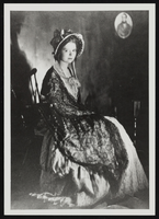
Clara Bow after winning the National Fame and Fortune Contest in New York City, New York: photographic print
Date
1921
Description
From the Nan Doughty Photograph Collection (PH-00240). Clara at age 16.
Image
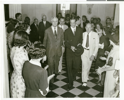
Photograph of Howard Hughes at the State Department, New York City, July 15, 1938
Date
1938-07-15
Archival Collection
Description
Typed onto a piece of paper attached to the image: "Howard Hughes walking along a hall at the State Department. Left to right: Jesse Jones, Howard Hughes, Harold Brayman, President of the National Press Club. July 1938."
Image
Edward P. Mulrooney, City of New York, New York Police Commissioner, foreword on gun control, approximately 1930 to 1931
Level of Description
File
Archival Collection
Howard Hughes Film Production Records
Archival Component