Search Results
New York-New York - Entryway, Las Vegas, Nevada: panoramic photograph
Date
Archival Collection
Description
From the Thomas Schiff Panoramic Photographs (PH-00419).
Image

Las Vegas City Commission Records
Identifier
Abstract
The Las Vegas City Commission Records (1911-1960) is comprised of bound and unbound materials from the original Las Vegas City Commission. Twelve of the bound volumes are minutes that served as the official record of the proceedings of all Las Vegas City Commission meetings from 1911-1960. There are also three volumes of City of Las Vegas ordinances dating from 1911 to 1958, one volume of legal documents from 1944-1945 and two large volumes containing an alphabetical subject index to the topics covered in the minutes. Unbound materials cover the period 1921 to 1946 and include minutes, resolutions, ordinances, correspondence, financial records, proclamations and other documents related to city business. They provide a valuable historical record of a wide variety of business and community activities in Las Vegas in the first fifty years of its incorporation.
Archival Collection
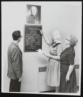
Photograph of Dorothy and others at Frazier Hall, Las Vegas (Nev.), 1962
Date
Archival Collection
Description
Image
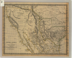
Map of Texas, California, New Mexico and the northern states of Mexico, October 15, 1842
Date
Description
Image