Search Results
North Las Vegas City Hall construction: digital photographs, 2010 October 04
Level of Description
File
Archival Collection
Bill Hughes Photographs
To request this item in person:
Collection Number: PH-00402
Collection Name: Bill Hughes Photographs
Box/Folder: Digital File 00
Collection Name: Bill Hughes Photographs
Box/Folder: Digital File 00
Archival Component
Crew of Anderson Brothers Mess Hall in Boulder City, Nevada: photographic print, 1932
Level of Description
Item
Archival Collection
UNLV Libraries Single Item Accession Photograph Collection
To request this item in person:
Collection Number: PH-00171
Collection Name: UNLV Libraries Single Item Accession Photograph Collection
Box/Folder: Folder 13
Collection Name: UNLV Libraries Single Item Accession Photograph Collection
Box/Folder: Folder 13
Archival Component
Photograph of town hall, Alamo (Nev.), 1910s - 1930s
Date
1910 to 1939
Archival Collection
Description
First town hall and Sunday meeting house in Alamo, Nevada. The town hall and meeting house was originally in Delamar, Nevada before 1910. The town hall in the photograph was replaced in 1939.
Image
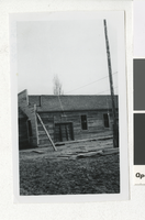
Civic Center Drive and North Las Vegas City Hall, 1970 May 23
Level of Description
File
Archival Collection
North Las Vegas Library Photograph Collection on North Las Vegas, Nevada
To request this item in person:
Collection Number: PH-00277
Collection Name: North Las Vegas Library Photograph Collection on North Las Vegas, Nevada
Box/Folder: Folder 05
Collection Name: North Las Vegas Library Photograph Collection on North Las Vegas, Nevada
Box/Folder: Folder 05
Archival Component

Chart, Comparative statement of water produced at Las Vegas for June and July in years between 1931 and 1938, June 9, 1938
Date
1938-06-09
Archival Collection
Description
Water production from five months between 1931 and 1938
Text
Jones, Florence Lee. The Junior Chamber Idea: Hits the West's Newest City, Trend, 1938 February
Level of Description
File
Archival Collection
UNLV Libraries Collection of Articles on Gaming and Las Vegas, Nevada Topics
To request this item in person:
Collection Number: MS-00626
Collection Name: UNLV Libraries Collection of Articles on Gaming and Las Vegas, Nevada Topics
Box/Folder: Box 13
Collection Name: UNLV Libraries Collection of Articles on Gaming and Las Vegas, Nevada Topics
Box/Folder: Box 13
Archival Component
Lewis, Fred, Letizia & Lewis publicity with president at City Hall, 1989 March 16
Level of Description
File
Archival Collection
Frank Mitrani Photographs
To request this item in person:
Collection Number: PH-00332
Collection Name: Frank Mitrani Photographs
Box/Folder: Box 29
Collection Name: Frank Mitrani Photographs
Box/Folder: Box 29
Archival Component
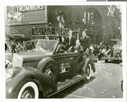
Photograph of Howard Hughes at his parade for Round the World flight, New York City, July 15, 1938
Date
1938-07-15
Archival Collection
Description
The black and white view of Howard Hughes (waving) seated in an automobile that was used in a parade dedicated to Hughes' completion of his Round the World flight in New York City, New York.
Image
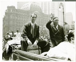
Photograph of Howard Hughes at his parade for Round the World flight, New York City, July 15, 1938
Date
1938-07-15
Archival Collection
Description
The view of Howard Hughes (left) and Mayor Fiorello Laguardia (right) seated in an automobile that was used in a parade dedicated to Hughes' completion of his Round the World flight in New York City, New York.
Image