Search Results
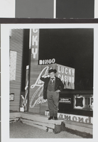
Photograph of an unidentified man in front of Lady Luck Casino, Las Vegas, circa early to mid 1900's
Date
1900 to 1939
Archival Collection
Description
An unidentified man posing in front of Lady Luck Casino in Las Vegas, Nevada. Site Name: Lady Luck Casino (Las Vegas, Nev.)
Image
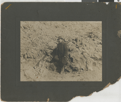
Photograph of Jim Butler standing by one of his first ore strikes in Tonopah, Nevada, circa 1900s
Date
1900 to 1909
Archival Collection
Description
Jim Butler standing by one of his first gold or silver ore strikes in Tonopah, Nevada.
Image
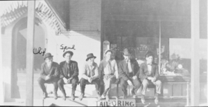
Film transparency of men sitting outside of a soda fountain, presumably Las Vegas, circa early 1900s
Date
1900 to 1910
Archival Collection
Description
Black and white image of several young men in hats sitting on a rail outside of a soda fountain and tailor shop, most likely in Las Vegas. The two men on the far left of the image are identified as "Cliff" and "Spud." Spud is probably Spud Lake.
Image

Film transparency of the basketball team for Clark County High School, Las Vegas, circa early 1900s
Date
1900 to 1939
Archival Collection
Description
Black and white image of the boys basketball team for Clark County High School, posing for a picture. Note: Image is from a family photo album that was loaned to UNLV Libraries Special Collections and returned to the family on July 17, 1984.
Image
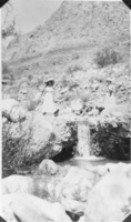
Film transparency of Olive Lake and Wanda Ball at Wilson's Ranch, Las Vegas, circa early 1900s
Date
1900 to 1910
Archival Collection
Description
Black and white image of Olive Lake and Wanda Ball standing next to a miniature waterfall at Wilson's Ranch.
Image
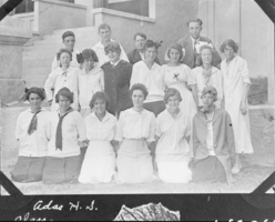
Film transparency of Ada Lake's high school class, presumably in Las Vegas, circa early 1900s
Date
1900 to 1939
Archival Collection
Description
Black and white image of Ada Lake's high school class, probably at Clark County High School in Las Vegas, Nevada. Handwritten in the bottom left corner: "Adas H.S." Note: Image is from a family photo album that was loaned to UNLV Libraries Special Collections and returned to the family on July 17, 1984.
Image

Photograph of a wagonload of lumber from Ed Von Tobel Lumber Company, Las Vegas, circa 1900s.
Date
1900 to 1909
Archival Collection
Description
Wagonload of lumber from Ed Von Tobel Lumber Co. Clark Forwarding Co., owned and operated by Ed W. Clark and Charles C. Ronnow, hauled the lumber and supplies. Physical object has an insert containg additional biographical information.
Image
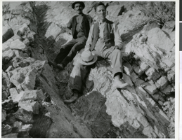
Photograph of Ed Von Tobel, Sr. exploring a mining claim, Las Vegas Region, circa 1900s
Date
1900 to 1909
Archival Collection
Description
Ed Von Tobel, Sr. and (possibly) Tony Felix on an exploring trip for mining claims in mountains surrounding Las Vegas. Physical object has an insert containing additional biographical information.
Image
Standing outside car is Mary Maris Garside and her father Robert Maris, inside car are Sherwin Garside, Frank Garside and Virginia Garside, 1925
Level of Description
File
Archival Collection
Sherwin "Scoop" Garside Photographs
To request this item in person:
Collection Number: PH-00067
Collection Name: Sherwin "Scoop" Garside Photographs
Box/Folder: Folder 01
Collection Name: Sherwin "Scoop" Garside Photographs
Box/Folder: Folder 01
Archival Component
Young girl posed next to baby doll in stroller in front of a fence with desert landscape in the background on Christmas morning: photographic print, 1925 December 25
Level of Description
Item
Archival Collection
Hazel Baker Denton Photograph Collection
To request this item in person:
Collection Number: PH-00312
Collection Name: Hazel Baker Denton Photograph Collection
Box/Folder: Folder 02
Collection Name: Hazel Baker Denton Photograph Collection
Box/Folder: Folder 02
Archival Component