Search the Special Collections and Archives Portal
Search Results
Transportation System Projects Fiscal Years 2010-2019 (Draft), 2009 July 22
Level of Description
Archival Collection
Pagination
- Previous page ‹‹
- Page 5
Archival Component

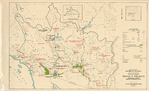
Map showing U.S. Bureau of Reclamation Region 3 projects in Arizona, California, Nevada, New Mexico and Utah, September 1967
Date
Description
Image
Archives and libraries
Level of Description
Archival Collection
Pagination
- Previous page ‹‹
- Page 5
Archival Component
Archived websites
Level of Description
Archival Collection
Pagination
- Previous page ‹‹
- Page 5
Archival Component
Archives, 1986
Level of Description
Archival Collection
Pagination
- Previous page ‹‹
- Page 5
Archival Component
Archives, 1983
Level of Description
Archival Collection
Pagination
- Previous page ‹‹
- Page 5
Archival Component

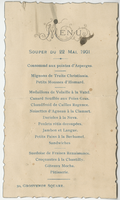
Unknown restaurant, dinner menu, May 22, 1901
Date
Archival Collection
Description
Text
Jarbidge, Nevada Community Archives Collection
Identifier
Abstract
The Jarbidge, Nevada Community Archives Collection contains scanned images from seven archival collections and document the community of Jarbidge, Nevada from approximately 1910 to 2006. The materials were collected from various families living in Jarbidge in 2006 as part of a project led by Carrie Townley Porter. The images depict early Jarbidge structures, surrounding landscape, the Elkoro Mine, and residents of the area. Also included are images of certificates, correspondence, and newspaper articles relating to the families' histories. Also included in the collection are written summaries of ten oral history interviews of Jarbidge residents conducted in 2006. This collection contains digital surrogates only; the owners and Jarbidge Community Archives retain the originals.
Archival Collection
Site Characterization and Validation: Final Report - Stripa Project 92-22, 1992 April
Level of Description
Archival Collection
Pagination
- Previous page ‹‹
- Page 5
Archival Component

Bridge Digital Archive Information
Date
Archival Collection
Description
Text
