Search the Special Collections and Archives Portal
Search Results
Louis Wiener, Jr. oral history project correspondence and transcript, 1990
Level of Description
File
Archival Collection
Valerie Wiener Papers
To request this item in person:
Collection Number: MS-01148
Collection Name: Valerie Wiener Papers
Box/Folder: Box 01
Collection Name: Valerie Wiener Papers
Box/Folder: Box 01
Archival Component

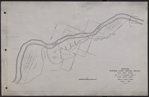
Map of proposed flood control project on the Virgin River in Clark County, Nevada, March, 1934
Date
1934-03
Archival Collection
Description
'Map no. 7 to accompany report on flood control survey. Made by Graham S. Quate. March 1934. Drawn by T.K.' Scale [ca. 1:15, 600. 1 in.=approx. 1,300 feet]. Relief shown by hachures. North oriented to upper right corner. Library's copy has hand-drawn map and notes in pencil on verso.
Image
Memorabilia gifted to Tabach from oral history projects, 2017 to 2020
Level of Description
File
Archival Collection
Barbara Tabach Papers
To request this item in person:
Collection Number: MS-01101
Collection Name: Barbara Tabach Papers
Box/Folder: Oversized Box 06
Collection Name: Barbara Tabach Papers
Box/Folder: Oversized Box 06
Archival Component
Bid tabulation booklet: multiple projects, 1970 April 22
Level of Description
File
Archival Collection
J. A. Tiberti Construction Records
To request this item in person:
Collection Number: MS-00855
Collection Name: J. A. Tiberti Construction Records
Box/Folder: Box 002
Collection Name: J. A. Tiberti Construction Records
Box/Folder: Box 002
Archival Component
Medical Advisory Panel Project Report, 1949 July 22
Level of Description
File
Archival Collection
Human Radiation Experiments Records
To request this item in person:
Collection Number: MS-00776
Collection Name: Human Radiation Experiments Records
Box/Folder: Box 01
Collection Name: Human Radiation Experiments Records
Box/Folder: Box 01
Archival Component
Worchester Banknote 1804-1866: the history of a New England bank, used as a guide for Nevada banking history project, 1966
Level of Description
File
Archival Collection
Nevada Banking History Collection
To request this item in person:
Collection Number: MS-00257
Collection Name: Nevada Banking History Collection
Box/Folder: Box 01
Collection Name: Nevada Banking History Collection
Box/Folder: Box 01
Archival Component
Mike Heidmann oral history interview, 2012 October 22
Level of Description
File
Scope and Contents
In 1990 Heidemann joined the Lovelock Volunteer Fire Department. He currently works at the Hawthorne Army Depot, Hawthorne Fire Department, and works as a Chief Training Officer and EMS Coordinator. He is also an instructor for the State Fire Marshall.
Archival Collection
History of Emergency Medical Services in Nevada Oral History Interviews
To request this item in person:
Collection Number: OH-00000
Collection Name: History of Emergency Medical Services in Nevada Oral History Interviews
Box/Folder: Digital File 00
Collection Name: History of Emergency Medical Services in Nevada Oral History Interviews
Box/Folder: Digital File 00
Archival Component
Fort Irwin Archaeological Project Report Number 22, 1986
Level of Description
File
Archival Collection
Elizabeth von Till and Claude N. Warren Professional Papers
To request this item in person:
Collection Number: MS-00906
Collection Name: Elizabeth von Till and Claude N. Warren Professional Papers
Box/Folder: Box 168 (Restrictions apply)
Collection Name: Elizabeth von Till and Claude N. Warren Professional Papers
Box/Folder: Box 168 (Restrictions apply)
Archival Component
Henry (Hank) Peluaga oral history interview, 2005 April 22
Level of Description
Item
Archival Collection
Nevada Test Site Oral History Project Records
To request this item in person:
Collection Number: MS-00818
Collection Name: Nevada Test Site Oral History Project Records
Box/Folder: Digital File 01
Collection Name: Nevada Test Site Oral History Project Records
Box/Folder: Digital File 01
Archival Component
Pagination
Refine my results
Content Type
Creator or Contributor
Subject
Archival Collection
Digital Project
Resource Type
Year
Material Type
Place
Language
Records Classification

