Search Results
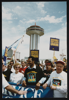
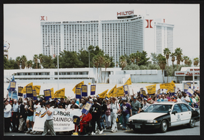
Frontier Strike: Jesse Jackson, Culinary Union, Las Vegas (Nev.), 1992 April 21 (folder 6 of 13), image 35
Date
1992-04-21
Description
Arrangement note: Series I. Demonstrations, Subseries I.A. Frontier Strike
Image
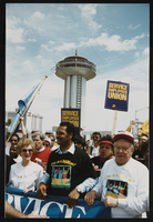
Frontier Strike: Jesse Jackson, Culinary Union, Las Vegas (Nev.), 1992 April 21 (folder 6 of 13), image 36
Date
1992-04-21
Description
Arrangement note: Series I. Demonstrations, Subseries I.A. Frontier Strike
Image

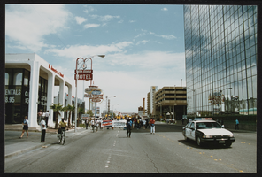
Frontier Strike: Jesse Jackson, Culinary Union, Las Vegas (Nev.), 1992 April 21 (folder 6 of 13), image 37
Date
1992-04-21
Description
Arrangement note: Series I. Demonstrations, Subseries I.A. Frontier Strike
Image

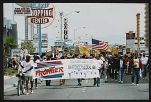
Frontier Strike: Jesse Jackson, Culinary Union, Las Vegas (Nev.), 1992 April 21 (folder 6 of 13), image 38
Date
1992-04-21
Description
Arrangement note: Series I. Demonstrations, Subseries I.A. Frontier Strike
Image
Frontier Strike: Jesse Jackson, Culinary Union, Las Vegas (Nev.), 1992 April 21 (folder 6 of 13), image 39
Date
1992-04-21
Description
Arrangement note: Series I. Demonstrations, Subseries I.A. Frontier Strike
Image

Frontier Strike: Jesse Jackson, Culinary Union, Las Vegas (Nev.), 1992 April 21 (folder 6 of 13), image 40
Date
1992-04-21
Description
Arrangement note: Series I. Demonstrations, Subseries I.A. Frontier Strike
Image

Frontier Strike: Jesse Jackson, Culinary Union, Las Vegas (Nev.), 1992 April 21 (folder 6 of 13), image 41
Date
1992-04-21
Description
Arrangement note: Series I. Demonstrations, Subseries I.A. Frontier Strike
Image
Frontier Strike: Jesse Jackson, Culinary Union, Las Vegas (Nev.), 1992 April 21 (folder 6 of 13), image 42
Date
1992-04-21
Description
Arrangement note: Series I. Demonstrations, Subseries I.A. Frontier Strike
Image
Frontier Strike: Jesse Jackson, Culinary Union, Las Vegas (Nev.), 1992 April 21 (folder 6 of 13), image 43
Date
1992-04-21
Description
Arrangement note: Series I. Demonstrations, Subseries I.A. Frontier Strike
Image

Frontier Strike: Jesse Jackson, Culinary Union, Las Vegas (Nev.), 1992 April 21 (folder 6 of 13), image 44
Date
1992-04-21
Description
Arrangement note: Series I. Demonstrations, Subseries I.A. Frontier Strike
Image