Search Results
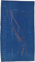
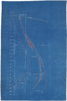
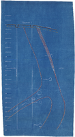
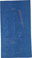

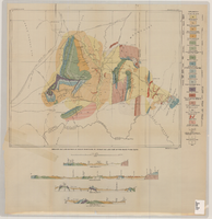
Geologic map and sections of area along Colorado River between Lake Mead and Davis Dam, Arizona and Nevada, 1963
Date
1963
Description
At top of map: 'United States, Department of Interior, Geological Survey. Professional Paper 374-E, plate 1.' In lower right corner of map: 'Geology mapped by C.R. Longwell.' Relief shown by contours. Includes seven colored cross-sections. Scale 1:125,000 (W 114°50´--W 114°20´/N 36°10´--N 35°10´). Series: Shorter contributions to general geology. Professional paper (Geological Survey (U.S.))374-E. Originally published as plate 1 in: Reconnaissance geology between Lake Mead and Davis Dam, Arizona-Nevada / by Chester R. Longwell, published by the U.S. Government Printing Office in 1963 in the series Shorter contributions to general geology and as Geological Survey professional paper 374-E.
Image
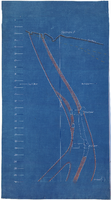
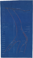
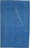
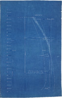
Geologic map and sections of Muddy Mountains, St. Thomas Gap, and part of the Grand Wash Cliffs, 1928
Date
1928
Description
'Geology by C.R. Longwell.' At top of map: 'U.S. Geological Survey Bulletin 798, plate 1.' Includes four colored cross-sections. 1:250,000 (W 115°00'--W 113°45'/N 36°45'--N 36°00'). Series: Bulletin (Geological Survey (U.S.)no. 798. Originally published as plate 1 in: Geology of the Muddy Mountains, Nevada, with a sections through the Virgin Range to the Grand Wash Cliffs, Arizona / by Chester R. Longwell. Washington, D.C. : Government Printing Office, 1928. (Bulletin ((Geological Survey (U.S.)), no. 798).
Image