Search Results
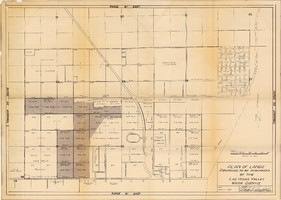
Map showing various facilities of the Las Vegas Land and Water Company, March 1, 1953
Date
1953-03-01
Archival Collection
Description
'Exhibit C.' 'March 1, 1953.' 'I-67.' Scale [ca. 1:7,200] 1 in.=600 feet. Map shows facilities [mainly water-pipes] of Las Vegas Land and Water Company completed and those under construction as of September 1, 1952, and facilities which were commenced after September 1, 1952, and prior to March 1, 1953. Map made as part of the papers for the sale of Las Vegas Land and Water Company facilities to the Las Vegas Valley Water District. Shows township and range lines. Library's copy has hand-written notes in pencil. Las Vegas Land and Water Company?
Image
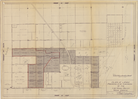
Map showing location of water-bearing lands to be sold to the Las Vegas Valley Water District, March 1, 1953
Date
1953
Archival Collection
Description
'Exhibit A.' 'March 1, 1953.' 'I-128.' Shows location of water-bearing lands to be sold to the Las Vegas Valley Water District and the boundary of lands owned by Union Pacific which are not to be sold to the district. The Union Pacific Railroad Company owned the Las Vegas Land and Water Company. Also shows pipes, proposed pipes, other parts of the water system, power lines, and lists power requirements for water system. Includes township and range lines. Las Vegas Land and Water Company
Image

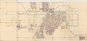
Plan of proposed new well pipe and fittings for Las Vegas, Nevada, 1936
Date
1936
Archival Collection
Description
Blueprint. Written on back of map:: 'Purposed [sic] new transmission lines--1936--transits.' Las Vegas Land and Water Company?
Image
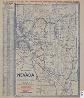
Sketch map of Nevada and the southeastern portion of California, 1906
Date
1906
Description
42 x 30 cm., fold. to 23 x 11 cm. Relief shown by hachures. Copyright: George S. Clason. "Compliments of D. Mackinzie & Company Incorporated, Mine Operators and Commission Brokers, Goldfield, Nevada." Company's locations in Goldfield and in Greenwater, California, are marked with red circles on the map. Includes index. Shows railroad routes. Original publisher: Clason Map Co..
Image


Map of well locations, Las Vegas Valley, Nevada, 1975
Date
1976
Description
'Cartography by Marj Thielke.' 'Prepared in cooperation with the State of Nevada, Department of Conservation and Natural Resources, Division of Water Resources.' Relief shown by contours. Shows township and range lines. Originally published as Plate 1 in Water-level changes associated with ground-water development in Las Vegas Valley, Nevada, 1971-75 : fourth progress report--summary of data / by James R. Harrill, published in 1976 by the Department of Conservation and Natural Resources, Division of Water Resources, as volume 22 of Water resources-information series report. Scale [ca. 1:69,696. 1 in.=approx. 1.1 miles] (W 115°20´--W 115°00´/N 36°20´--N 36°00´).
Image

Geologic map of Las Vegas Valley, Nevada, 1982
Date
1982
Description
At top of map:'Department of the Interior, U.S. Geological Survey. Prepared in cooperation with the Clark County Department of Comprehensive Planning. Water supply paper 2320-A, plate 1.' At bottom of map: ' Base from U.S. Geological Survey, 1:100,000, Boulder City, Ariz.-Nev., Las Vegas, Nev.-Calif., Mesquite Lake, Nev.-Calif., 1978; Lake Mead, Nev.-Ariz., 1979. Geology from Malmberg (1965); Longwell and others (1965); Haynes (1967); Bingler (1977); Bell and Smith (1980); Bell (1981); Matti and Bachhuber (1982); and Matti and Morton (1982a, b); modified by R. W. Plume, 1981.' Shows township and range lines. Scale 1:100,000 (W 115°30´--W 115°00´/N 36°30´--N 36°00´). Series: U.S. Geological Survey water-supply paper2320-A. Originally published as plate 1 of Ground-water conditions in Las Vegas Valley, Clark County, Nevada. Part I. Hydrogeologic framework / by Russell W. Plume, published by the U.S. Geological Survey in 1989 as Water-supply paper 2320-A.
Image