Search Results
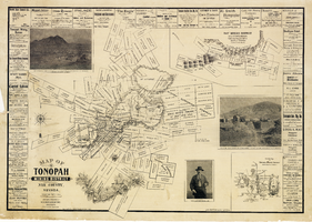
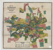
Map of the Tonopah Mining District, Nye County (Nev.), 1902
Date
1902
Description
Map of the Tonopah Mining District, Nye County (Nev.), 1902
Image
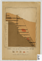
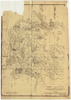
Map of a vertical cross-section through the Eureka Consolidated Mine, Eureka County (Nev.), 1883
Date
1883
Description
Scale [ca. 1:2,400] 1 in.=200 feet1 map ; col. ; 20 x 16 cm ; Eureka Con. Mine is in the Eureka Mining District in Nevada ; "Juliue Bien & Co. lith." ; "U.S. Geological Survey. Annual report 1883, pl. XXXIII"--Upper right margin ; Library's copy has "Nev." printed in pencil in upper right corner
Image
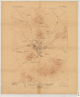
Map of the Tonopah Mining District, Tonopah (Nev.), 1910
Date
1910
Description
Ed. of Mar. 1904, reprinted Apr. 1910 ; Scale 1:12,000 (W 117 14'--W 117 12'/N 38 05'--N 38 03') ; 1 map : col. ; 41 x 31 cm ; Oriented with north toward the upper left ; Relief shown by contours and hachures ; Topography by W.J. Peters ; "Surveyed in 1902-1903." ; "Triangulation by U.S. Coast and Geodetic Survey." ;
Image
Map of the Tonopah Mining District, Nye County (Nev.), 1905
Date
1905
Description
Scale [ca.1:12,804. 1 in. to approx. 1,067 ft.] ; 1 map ; on sheet 92 x 106 cm ; Relief shown by hachures ; Title supplied by cataloger ; Probably a preliminary black and white edition of the colored map copyrighted by Bradford and Bradford in 1905
Image
Map of the Tonopah Mining District, Nye County (Nev.), 1905
Date
1905
Description
Scale [ca. 1:15,600. 1 in. to approx. 1300 feet] ; 1 map : col. ; 60 x 64 cm ; Relief shown by hachures ; Copyright held by Bradford & Bradford ; Includes table of distances ; Library's copy has one section outlined in red pencil and Tonopah Victor printed on it in red pencil. Red pencil dots are on two other sections. 1905 printed in pencil and some unreadable words written in pencil near title of map ;
Image
Map of approved mineral surveys in the Goldfield Mining District, Goldfield (Nev.), 1908
Date
1908
Description
Scale [ca. 1:9,600]. 1 in. to 800 feet. (W 117 14'--W 117 09'/N 37 46'--N 37 41') ; 1 map ; 129 x 97 cm ; Blueline print ; Includes township and range grid ; "Copyright 1908 by Davis and Byler. 1911." ; Library's copy has upper-left corner torn off and has circles drawn around and diagonal lines drawn on certain claims ;
Image
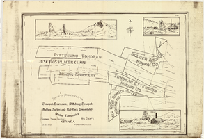
Map of the properties of the Tonopah Extension, Pittsburg Tonopah, Golden Anchor, and Red Rock Consolidated Mining Companies : Tonopah Mining District, Nye County (Nev.), 1901
Date
1901
Description
Scale [ca. 1:2,400] 1 in. to 200 feet ; 1 map ; 75 x 102 cm; Includes locations of mines and their main shafts and drawings of the hoists of the Tonopah Extension, Golden Anchor and the Red Rock Consolidated ; Photocopy. [United States : s.n., 198-?]
Image
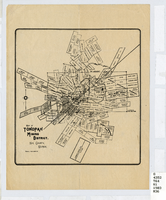
Map of the Tonopah Mining District, Nye County (Nev.), 1903
Date
1903
Description
Scale [ca. 1:7,200]. 1 in. equals 600 feet ; 1 map ; 17 x 16 cm ; Relief shown by hachures ; Library's copy has some mines cross-hatched in pencil ;
Image
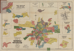
Map of the Tonopah Mining District, Tonopah (Nev.), 1903
Date
1903
Description
Rev. ed. ; Scale [ca. 1:10,800]. 1 inch to 900 feet ; 1 map : col. ; 76 x 102 cm., folded in cover to 21 x 11 cm ; Relief shown by hachures ; Cover title: Map of Tonopah, Gold Mountain and other adjacent mining districts, Nye and Esmeralda Counties ; Insets: Ray Mining District, vicinity map of Tonopah Mining District, Utopia Mining District, Tokop Mining District, Weepah Mining District, East Klondike Mining District, Gold Mountain, Tonopah Mining District and Red Mountain ; "Photo-lith. Britton & Rey, S.F." ; Includes advertisements
Image
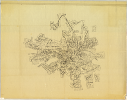
Map of the Mohawk Mine, 3rd level, Esmeralda County (Nev.), 1900-1925
Date
1900 to 1925
Description
Sectional mining map; hand-drawn and annotated in colored pencil
Image