Search Results
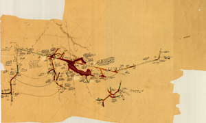
Map of the Clermont Mine, 4th level, Nye County (Nev.), 1900-1925
Date
1900 to 1925
Description
Sectional mining map; hand-drawn and annotated in colored pencil
Image
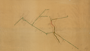
Map of the Clermont Mine, 6th level, Nye County (Nev.), 1900-1925
Date
1900 to 1925
Description
Sectional mining map; hand-drawn and annotated in colored pencil
Image
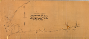
Map of the underground workings in Potosi and Central Lodes of Potosi Mining Group, Lincoln County (Nev.), May, 1906
Date
1906-05
Description
Map of the underground workings in Potosi and Central Lodes of Potosi Mining Group, Lincoln County (Nev.), May, 1906
Image
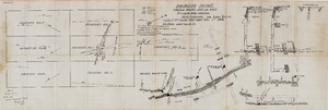
Map of the Fairday Mine, Cactus Range, Nye County (Nev.), May 25, 1916
Date
1916-05-25
Description
Scale 200 ft. to one inch.
Image
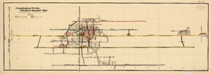
Map of the Longitudinal Section, Montana Tonopah Mine, Nye County (Nev.), 1900-1925
Date
1900 to 1925
Description
Map of the Longitudinal Section, Montana Tonopah Mine, Nye County (Nev.), 1900-1925
Image
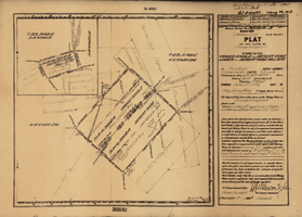
Plat map of the claim of George Wingfield (Yankee Doodle and Desert Rose Lodes), Esmeralda County (Nev.), 1910
Date
1910
Description
Plat map of the claim of George Wingfield (Yankee Doodle and Desert Rose Lodes), Esmeralda County (Nev.), 1910
Image
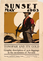
Poster of the cover of Sunset magazine, May 1903
Date
1903-05
Description
Poster of the cover of Sunset magazine, May 1903
Image
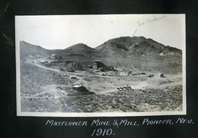
Photograph of buildings at the Mayflower Mine, Pioneer (Nev.), 1910
Date
1910
Archival Collection
Description
Annotated: Tex Rickards [top right]
Caption: Mayflower Mine and Mill, Pioneer, Nev. 1910.
Caption: Mayflower Mine and Mill, Pioneer, Nev. 1910.
Image
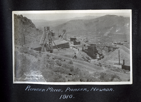
Photograph of the Pioneer Mine and a man on the hillside, Pioneer (Nev.), 1910
Date
1910
Archival Collection
Description
Annotated: Pioneer Mine July-1910; E. Davis [center]
Caption: Pioneer Mine, Pioneer, Nevada. 1910.
Caption: Pioneer Mine, Pioneer, Nevada. 1910.
Image
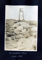
Photograph of a mining headframe at the Yellowjacket Mine, Pioneer (Nev.), 1911
Date
1911
Archival Collection
Description
Caption: Yellowjacket Mine June, 1911.
Image