Search Results
Photograph showing an aerial view of the twelve central girders installed to support the Mike O'Callaghan-Pat Tillman Memorial Bridge deck, Nevada-Arizona border, February 3, 2010
Date
2010-02-03
Archival Collection
Description
Photographer's notes: "Aerial view showing the twelve central girders installed as support for the eventual bridge deck, February 3, 2010." Site Name: Mike O'Callaghan-Pat Tillman Memorial Bridge
Image
Photograph of a line of floats crossing Lake Mead to set a boundary for boats nearing Hoover Dam, February 3, 2010
Date
2010-02-03
Archival Collection
Description
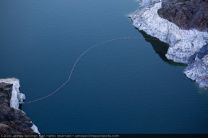
Photographer's notes: "A line of floats crosses Lake Mead as a boundary for boats getting near the dam, February 3, 2010. Note: Old photos from previous decades show people in boats water skiing, fishing, and even touching the dam."
Image
Photograph showing an aerial view of the Hoover Dam bypass highway intersecting with the original road leading to the dam, Arizona border, February 3, 2010
Date
2010-02-03
Archival Collection
Description
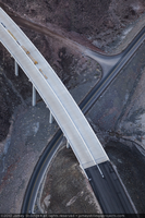
Photographer's notes: "Aerial view of the old road and the new bypass highway as they intersect on the Arizona side of the project, February 3, 2010." Site Name: Mike O'Callaghan-Pat Tillman Memorial Bridge
Image
Photograph showing an aerial view of Black Canyon and the Colorado River, downstream from Hoover Dam and the Mike O'Callaghan-Pat Tillman Memorial Bridge, Nevada-Arizona border, February 3, 2010
Date
2010-02-03
Archival Collection
Description
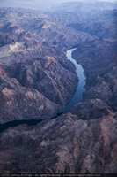
Photographer's notes: "Aerial view of the Black Canyon and Colorado River downstream from both the dam and bridge, February 3, 2010."
Image
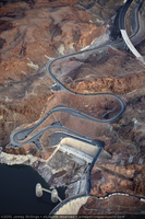
Photograph showing an aerial view of the original winding road descending to Hoover Dam with the new bypass road under construction in the upper right, Arizona border, February 3, 2010
Date
2010-02-03
Archival Collection
Description
Photographer's notes: "Aerial view of the winding original road descending to the dam on the Arizona side with the new bypass road under construction in the upper right, February 3, 2010." Site Name: Mike O'Callaghan-Pat Tillman Memorial Bridge
Image
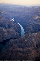
Photograph of the Colorado River and Black Canyon, Nevada-Arizona border, February 3, 2010
Date
2010-02-03
Archival Collection
Description
Photographer's notes: "Downstream from the dam, the Colorado River resumes its journey through a rugged Black Canyon."
Image
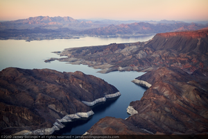
Photograph of Lake Mead, February 3, 2010
Date
2010-02-03
Archival Collection
Description
Photographer's notes: "Lake Mead remains the largest reservoir in the United States. The white banding is caused by mineral deposits that show how high the water level would be, if the reservoir were full."
Image
Photograph of the twelve central girders installed as support for the deck of the Mike O'Callaghan-Pat Tillman Memorial Bridge, Nevada-Arizona border, February 3, 2010
Date
2010-02-03
Archival Collection
Description
Photographer's notes: "Aerial view showing the twelve central girders installed as support for the eventual bridge deck, February 3, 2010." Site Name: Mike O'Callaghan-Pat Tillman Memorial Bridge
Image
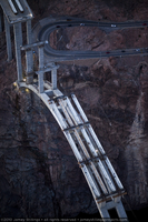
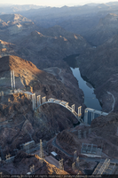
Photograph of the twelve central girders installed as support for the deck of the Mike O'Callaghan-Pat Tillman Memorial Bridge, Nevada border, February 3, 2010
Date
2010-02-03
Archival Collection
Description
Photographer's notes: "Aerial view showing the twelve central girders installed as support for the eventual bridge deck and the Nevada side hairpin turn, February 3, 2010." Site Name: Mike O'Callaghan-Pat Tillman Memorial Bridge
Image
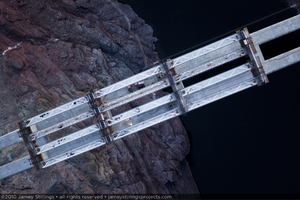
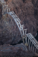
Photograph of the twelve central girders installed as support for the deck of the Mike O'Callaghan-Pat Tillman Memorial Bridge, Nevada-Arizona border, February 3, 2010
Date
2010-02-03
Archival Collection
Description
Aerial view down on twelve girders spanning the central pier caps. Site Name: Mike O'Callaghan-Pat Tillman Memorial Bridge
Image