Search Results
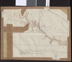
Topographic map of Arrow Canyon dam and reservoir site on the Muddy River, 1934
Date
1934
Archival Collection
Description
'Topography by Lee Morrison. Control by U.S. Geological Survey and U.S. Bureau of Reclamation. Surveyed in 1934.' Relief shown by contours and spot heights. 'Arrowhead Canyon Dam and reservoir site' hand-written on map. Map is part of a larger map and has been taped to a manila envelope sent from the Agricultural Administration to J.H. Wittwer on Sept. 25, 1939. Map has hand-drawn township and range lines and handwritten numbers. Verso has a hand-drawn map, calculations, and hand-written notes. U.S. Geological Survey
Text
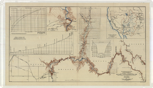
Topographic map of the Boulder Canyon Reservoir site, 1930
Date
1930
Description
Scale [ca. 1:144,000. 1 in. to approx. 12,000 ft.] ; 1 map : col. ; 51 x 91 cm ; Relief shown by contours and spot heights ; "Map no. 23800" ; Includes township and range grid ; Includes two profile diagrams, area and capacity curve diagram, Topography of Black Canyon and vicinity map and Colorado River basin map. Inset maps of Black Canyon and vicinity and Colorado River Basin. Inset charts of Boulder Canyon Reservoir Area and Capacity Curves; and, Profile of Colorado River from Bridge Canyon Dam Site, Arizona to Black Canyon Dam Site, Arizona-Nevada. Bureau of Reclamation.
Image
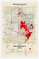
Map showing home-site lands in the Las Vegas Valley, 1955
Date
1955
Description
Scale [1:84,269. 1 in. to 1 1/3 miles] ; 1 map : col. ; 57 x 50 cm. on sheet 89 x 59 cm ; Cadastral map ; Gives definition of township, section and acre ; Relief shown by form lines and spot heights ; Shows private land, land classified for small tracts, leased land, vacant Federal land, section numbers, number of acres in each homesite and purchase price of tract ; "From your Congressman Cliff Young."--stamped on map ; Southern Nevada Home-Siters
Image
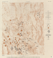
Map showing ground-water chemistry and hydrochemical facies, Nevada Test Site and vicinity, southern Nevada, 1965
Date
1965
Description
'United States Department of the Interior, Geological Survey. Professional paper 712-C, plate 3.' 'Prepared on behalf of the Atomic Energy Commission.' 'Base from U.S. Geological Survey Caliente, Death Valley, Goldfield, and Las Vegas, 1954.' 'Hydrochemistry by I. J. Winograd, 1965.' 'Interior--Geological Survey, Reston, Virginia--1975.' Relief shown by contours. Contour interval 200 feet. Shows township and range lines. Scale 1:250,000 (W 117°--W 115°/N 38°--N 36°). Series: Professional paper (Geological Survey (U.S.))712-C. Issued as plate 3 from U.S. Geological Survey professional paper 712-C, Hydrogeologic and hydrochemical framework, south-central Great Basin, Nevada-California, with special reference to the Nevada Test Site, by I.J. Winograd, and William Thordarson, published in 1975 by the U.S. Geological Survey.
Image
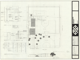
Architectural drawing of additions to the Mather residence, Las Vegas, Nevada, site plan, floor plan and details, October 14, 1975
Date
1975-10-14
Archival Collection
Description
Site plan of the existing structure and additions to the Mather residence in Las Vegas, Nevada, including floor plans and details for a garage and additional bedroom. Included are the garage floor plan, drawings of the front exterior and entry elevations, and details for a skylight and the patio ceiling. "Date: 14 Oct. 1975, revisions: 15 Oct. 1975."
Site Name: Mather residence
Address: 2800 Cowan Circle;
Image
Nevada Test Site: Annual Site Environmental Report, 1994
Level of Description
File
Archival Collection
Yucca Mountain Site Characterization Office Collection
To request this item in person:
Collection Number: MS-00091
Collection Name: Yucca Mountain Site Characterization Office Collection
Box/Folder: Box 39
Collection Name: Yucca Mountain Site Characterization Office Collection
Box/Folder: Box 39
Archival Component
Yucca Mountain Site Characterization Project: Site Atlas, 1997
Level of Description
File
Archival Collection
Yucca Mountain Environmental Safety Reports Collection
To request this item in person:
Collection Number: MS-00786
Collection Name: Yucca Mountain Environmental Safety Reports Collection
Box/Folder: Box 35
Collection Name: Yucca Mountain Environmental Safety Reports Collection
Box/Folder: Box 35
Archival Component
On Site Images
Level of Description
File
Archival Collection
Jamey Stillings Photograph Collection
To request this item in person:
Collection Number: PH-00380
Collection Name: Jamey Stillings Photograph Collection
Box/Folder: N/A
Collection Name: Jamey Stillings Photograph Collection
Box/Folder: N/A
Archival Component
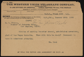
Town site
Date
1905
Archival Collection
Description
Series 1. San Pedro, Los Angeles and Salt Lake Railroad -- J. Ross Clark/Los Angeles Office Files
Mixed Content
Yucca Mountain Site Characterization Project: Site Atlas, 1993-1994
Level of Description
File
Archival Collection
Yucca Mountain Environmental Safety Reports Collection
To request this item in person:
Collection Number: MS-00786
Collection Name: Yucca Mountain Environmental Safety Reports Collection
Box/Folder: Box 34
Collection Name: Yucca Mountain Environmental Safety Reports Collection
Box/Folder: Box 34
Archival Component