Search the Special Collections and Archives Portal
Search Results

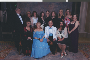
Photographs of Las Vegas Senior Lifeline Senior Prom at Caesars Palace, April 22, 2006
Date
Archival Collection
Description
Photographs of the Senior Lifeline Senior Prom.
Image
Oral history project planning documents, guidelines, research, 1994-2004
Level of Description
Archival Collection
Collection Name: History of Nursing in Southern Nevada Oral History Project Records
Box/Folder: Box 01 (Restrictions apply)
Archival Component

Video, News 13 segment on the growth of Jewish population in Las Vegas, March 22, 1999
Date
Archival Collection
Description
Segment from News 13 on the Jewish community in Las Vegas and Henderson, Nevada.
Moving Image
Cornerstone ceremony at the new Las Vegas High School, Las Vegas, Nevada, photograph and negative, 1930 February 22
Level of Description
Archival Collection
Collection Name: Elton and Madelaine Garrett Photograph and Architectural Drawing Collection
Box/Folder: Folder 06, Box 19
Archival Component
Cornerstone ceremony at the new Las Vegas High School, Las Vegas, Nevada, photograph and negative, 1930 February 22
Level of Description
Archival Collection
Collection Name: Elton and Madelaine Garrett Photograph and Architectural Drawing Collection
Box/Folder: Folder 06, Box 19
Archival Component
Cornerstone ceremony at the new Las Vegas High School, Las Vegas, Nevada, photograph and negative, 1930 February 22
Level of Description
Archival Collection
Collection Name: Elton and Madelaine Garrett Photograph and Architectural Drawing Collection
Box/Folder: Folder 06, Box 19
Archival Component
J. K. Russ oral history interview
Identifier
Abstract
Oral history interview with J. K. Russ conducted by Claytee D. White on December 22, 2017 for the Remembering 1 October Oral History Project. In this interview, Russ discusses her early life in New Zealand and growing up on a tobacco farm. She remembers arriving to the United States and establishing a career as an artist. Russ talks about the 1 October shooting, creating an art exhibit using cards and letters received from people all over the world, and Las Vegas’ response to the tragedy. Lastly, Russ describes the art community in Las Vegas and the Arts District.
Archival Collection

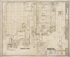
Architectural drawing of Sahara Hotel Convention Center (Las Vegas), ground and pavilion floor plan, March 22, 1967
Date
Archival Collection
Description
Architectural plans for the Sahara Hotel Convention Center from 1967. Includes revisions, notes, and banquet room capacities. Printed on mylar. Berton Charles Severson, architect; Brian Walter Webb, architect; Masyoshi Tokubo, delineator.
Site Name: Sahara Hotel and Casino
Address: 2535 Las Vegas Boulevard South
Image
Megan Griffard oral history interview, 2024 August 22
Level of Description
Scope and Contents
Oral history interview with Megan Griffard conducted by Claytee D. White and Stefani Evans on August 22, 2024 for the UNLV Remembers: an Oral History of the 6 December 2023 Shootings project. In this interview, Griffard, UNLV assistant professor in the educational policy and leadership program, describes taking her 18-month-old daughter to the UNLV/CSUN Preschool on the UNLV campus before going to her office. She initially planned to go to the Student Union, where her colleagues had prepared poster presentations when she received the first alert and hid under her desk. Her husband called to tell her he had been called to prepare for mass casualties at UMC and the freeway was closed. She texted her dad, her coworkers, and called the preschool while hiding under her desk. She describes trying to get to the Methodist Church across Maryland Parkway, the designated spot for the preschool parents to be transported to the preschool to pick up their children. When her turn finally came, she was driven to the school and passed through layers of security before she could retrieve her daughter. Her husband soon arrived and the family was eventually able to go home together. The next day, Griffard returned to campus with her colleague who had been in the Student Union. The following Monday, Griffard and her coworkers held a Zoom meeting to check in with each other and talk about their experiences. She talks about the importance of finding the right therapist, learning how to process painful events, and realizing how her recovery has helped her shut down a tendency to people-please. Digital audio and transcript available.
Archival Collection
Collection Name: UNLV Remembers: an Oral History of the 6 December 2023 Shooting interviews
Box/Folder: Digital File 00 (Restrictions apply)
Archival Component

