Search Results
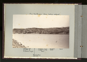
Photograph of Eldorado Canyon from the Arizona shore, Eldorado Canyon (Nev.), 1900-1925
Date
1900 to 1925
Description
Caption: From the Arizona Shore, looking southwest [above]. S.W.M. Co. Mill at outlet of El Dorado Canyon, Store building, end view, Millmen's camps and cabins on "the Mesa", abandoned adobe, home [below]
Image
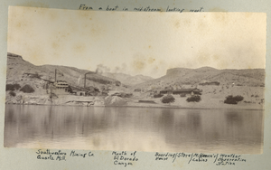
Photograph of Eldorado Canyon taken from the Colorado River, Eldorado Canyon (Nev.), 1900-1925
Date
1900 to 1925
Description
Caption: From a boat in mid-stream, looking west. [above] Southwestern Mining Co. Quartz Mill, Mouth of El Dorado Canyon, Boarding House, Store, Millmen's cabins, Weather Observation Station [below]
Image
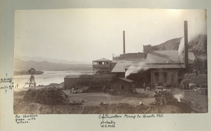
Photograph of the Southwestern Mining Company's Quartz Mill along the river, Eldorado Canyon (Nev.), 1900-1925
Date
1900 to 1925
Description
Annotated: ? G.B. Waterhouse Mills N.W. [bottom left], Far shoreline green with willows. [bottom left corner], probably W.S. Mills [bottom center]
Caption: Southwestern Mining Co. Quartz Mill.
Site Name: Southwestern Mining Company Quartz Mill (Clark County, Nev.)
Caption: Southwestern Mining Co. Quartz Mill.
Site Name: Southwestern Mining Company Quartz Mill (Clark County, Nev.)
Image
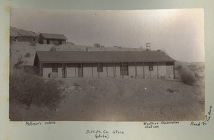
Photograph of the company store, Millmen's cabins, and the Weather Observation Station, Eldorado Canyon (Nev.), 1900-1925
Date
1900 to 1925
Description
Caption: Millmen's cabins, S.W.M. Co. store (adobe), Wather Observation Station, Road to the house [with arrow point to the right]
Image
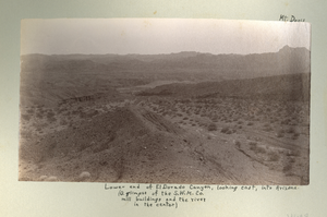
Photograph of Eldorado mill buildings, river, and Mount Davis, Eldorado Canyon (Nev.), 1900-1925
Date
1900 to 1925
Description
Annotated on top right: Mt. Davis
Caption: Lower end of El Dorado Canyon, looking east, into Arizona. (A glimpse of the S.W.M.Co. mill buildings and the river in the center)
Site Name: Southwestern Mining Company Quartz Mill (Clark County, Nev.)
Caption: Lower end of El Dorado Canyon, looking east, into Arizona. (A glimpse of the S.W.M.Co. mill buildings and the river in the center)
Site Name: Southwestern Mining Company Quartz Mill (Clark County, Nev.)
Image
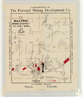
Map of the Bullfrog Mining District, Nye County (Nev.), 1905
Date
1905
Description
Scale [ca. 1:39,000. 1 in. to approx. 3,250 feet] ; 1 map : col. ; 45 x 38 cm ; Relief shown by hachures ; "Compliments of the Forward Mining Development Co." ; Properties owned by Patrick Investment Company are marked in red ; Shows railroads, roads, and pipelines ;
Image
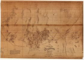
New official map of the Bullfrog Mining District, Nye County (Nev.), 1905
Date
1905
Description
Scale [ca. 1:16,800. 1 inch to approximately 1,400 feet] ; 1 map ; 74 x 109 cm ; Blueline print ; Scale almost illegible ; "Photo. lith. Britton & Rey." ; Photocopy? [United States : s.n., 199-?] ;
Image
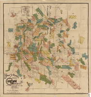
Elmer J. Chute's Map of Goldfield Mining District, Esmeralda and Nye Counties (Nev.), 1905
Date
1905
Description
Scale [ca. 1:20, 400. 1 in.=aprrox. 1,700 feet] ; 1 map : col. ; 60 x 58 cm ; Includes inset location map ; Includes township and range grid ;
Image
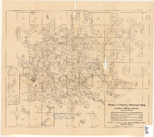
Elmer J. Chute's Diamond Map of the Goldfield Mining District, Esmeralda and Nye Counties (Nev.), 1907
Date
1907
Description
Elmer J. Chute's Diamond Map of the Goldfield Mining District, Esmeralda and Nye Counties (Nev.), 1907
Image