Search Results

Topographic map of groundwater in the southeast quadrangle of Las Vegas, Nevada, 1980
Date
1980
Description
'Las Vegas Area Map 3Af.' 'Prepared in cooperation with U.S. Geological Survey.' 'Water Resources Division, U.S. Geological Survey, Carson City, Nevada.' 'Topographic base from U.S. Geological Survey, Las Vegas SE 7 1/2 quadrangle, 1967.' Scale 1:24,000 (W 115°07'30"--W 115°00'00"/N 36°07'30"--N 36°00'00"). Series: Las vegas area map ; 3Af. Urban area maps. Las Vegas area map ; 3Af. Relief shown by contour lines and spot heights. Title in margins of map: Las Vegas SE quad. : ground water. Title on publications list on Nevada Bureau of Mines and Geology website: Groundwater map of the Las Vegas SE quadrangle. Series: Urban area maps [Las Vegas area map] from publications list on Nevada Bureau of Mines and Geology website. Nevada Bureau of Mines and Geology
Text

Map showing parts of eastern and southeastern Nevada and southwestern Utah, circa 1873
Date
1869
1872 to 1873
Archival Collection
Description
Scale 1:506,880. 1 in. to 8 miles (W 117°30--W 114°45/N 37°20--N 40°00). Relief shown by hachures and spot heights. At top left: 'Explorations & surveys west of the one-hundredth meridian.' At top right: 'Parts of Eastern & Southeastern Nevada & Southwestern Utah. Atlas sheet number 66.' At bottom left: 'Expeditions of 1869, 1872 & 1873.' At bottom right: ' 1st Lieut. Geo. M. Wheeler, Corps of Engineers, com'd'g.' Seal of the War Department, Corps of Engineers, U.S. Army at top center of map. Originally published as part of the geological atlas which is an appendix to the Survey's Report upon United States geographical surveys west of the one hundredth meridian, published in 1876?
Image
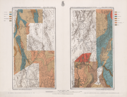
Maps of geographical surveys of parts of California, southeastern Nevada, Arizona and southwestern Utah, made under the command of George M. Wheeler, 1872-1873
Date
1872 to 1873
Description
At top of plate: 'U.S. geographical surveys west of the one-hundredth meridian. Parts of California, S.E. Nevada, Arizona & S.W. Utah.' At bottom of plate: 'Expeditions of 1872 & 1873, under the command of 1st Lieut. Geo. M. Wheeler, Corps of Engineers, U.S. Army.' 'G. K. Gilbert, A. R. Marvine, E. E. Howell, geological assistants.' 'By order of The Honorable The Secretary of War, under the direction of Brig. Gen. A. A. Humphries, Chief of Engineers, U.S. Army.' Published by Government Printing Office. 2 map sections on 1 sheet. Scale: 1 inch to 8 miles.
Image