Search Results
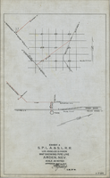
Map showing water pipeline in Arden, Nevada, May 4, 1913
Date
1913-05-04
Archival Collection
Description
'Exhibit A. S.P.L.A. & S.L.R.R. Los Angeles Division.' 'Approved May 4, 1913 [signed] E.M. Jessup, E.M. of W.' 'I-T-54.'
Image

Map showing proposed new 12" well and pipe line changes at Water Springs, Las Vegas, Nevada, circa 1920
Date
1916 to 1925
Archival Collection
Description
In lower right corner: '6-W-74.' Scale: 1" = 500'.
Image
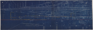
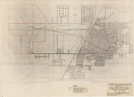
Map showing possible industrial users' connections to railroad pipelines in Las Vegas, Nevada, December 4, 1930
Date
1930-12-04
Archival Collection
Description
Stamped portion near lower right corner reads 'Union Pacific System, L.A. & S.L. R.R. Scale: 1" = 100'. Date: 12-4-30. Office Division, Eng'r. Los Angeles. Drg. No. 916.' 10 3/4 in. x 33 3/4 in. Scale: 1" = 100"..
Image
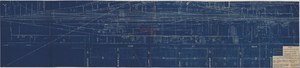
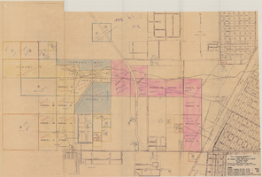
Map showing location of proposed water lines serving Industrial Tract No. 1, Las Vegas Nevada, March 21, 1931
Date
1931-03-21
Archival Collection
Description
'Office of Ind'l. Engineer, Los Angeles, California.' 'Dwg. No. 568.' Scale: 1" = 100'.
Image
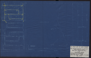
Map showing location of proposed water mains to serve Hyde Park Subdivision No. 2 at Las Vegas, Nevada, April 21, 1953
Date
1953-04-21
Archival Collection
Description
'Drawing B-617.' 'Office of Vice President, Los Angeles,California.' Accompanies: L. R. Maag letter to Thomas A. Campbell, June 15, 1953 (Box 14 Folder W26 File No. 1).
Image
Map to accompany agreement with Las Vegas Land and Water Company covering furnishing of water by UPRRCo. to LVL&WCo. at Las Vegas, Nevada, October 4, 1950
Date
1950-10-04
Archival Collection
Description
'Los Angeles & Salt Lake Railroad Company, Union Pacific Railroad Company, Exhibit A.' 'Office of Vice President-LVL&WCompany, Los Angeles, California, October 4, 1950.'
Image
Map to accompany Appraisal of water lands of Los Angeles & Salt Lake Railroad Company, Las Vegas, Nevada, August 19, 1952
Date
1952-08-19
Archival Collection
Description
'Office of General Land and Tax Agent, Los Angeles, California, August 19, 1952.' 'Parcels numbered as shwon on Water District map.' Scale: 1" = 600'.
Image

Official Arrow city map, Las Vegas & vicinity, Nevada, circa 1957-1961
Date
1957 to 1961
Description
71 x 68 cm. on sheet 106 x 71 cm., folded in cover 25 x 12 cm. Cover title: Latest edition, city map and street index of "fabulous" Las Vegas and vicinity, Nevada. Publisher from cover. "H-654-32." Includes indexes. Inside of cover includes information on Las Vegas. Includes inset maps of Boulder City, Nevada, and Las Vegas's location. Original publisher: R. L. Polk.
Image

Geologic map of the Paiute Ridge quadrangle, Nye and Lincoln Counties, Nevada, 1967
Date
1967
Description
58 x 46 cm., on sheet 85 x 83 cm., fold. in envelope 30 x 24 cm. Relief shown by contours and spot heights. "Contour interval 20 feet." "Prepared in cooperation with the U.S. Atomic Energy Commission." "Geology mapped in 1961. Contours on pre-Tertiary rocks by D. L. Healey and C. H. Miller, 1963." Includes text, 4 col. cross sections, and quadrangle location map. Original publisher: U. S. Geological Survey, Series: Geologic quadrangle map GQ, Scale: 1:24 000.
Image

Geologic map of the Lathrop Wells quadrangle, Nye County, Nevada, 1970
Date
1970
Description
58 x 47 cm., on sheet 74 x 84 cm., folded in envelope 30 x 24 cm. Relief shown by contours and spot heights. "Bedrock geology mapped by B.C. Burchfiel, 1961, and by E.J. McKay and K.A. Sargent, 1965-66. Surficial geology mapped by A.T. Fernald, 1968." Includes cross sections, description of map units, and location map. "Prepared in cooperation with the U. S. Atomic Commission." Original publisher: Interior, Geological Survey, Series: Geologic quadrangle map GQ, Scale: 1:24 000.
Image