Search Results
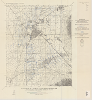
Map of part of Las Vegas Valley, Nevada, showing the approximate piezometric surface in 1912
Date
1965
Description
'Base by U.S. Geological Survey, 1952.' 'Interior--Geological Survey, Washington, D.C.--1965--W63358.' 'Compiled from data published by Carpenter (1915), Kearney (1913), and McWilliams (1913).' Relief shown by contours. Includes township and range lines. Scale 1:62,500 (W 115°15´--W 115°00´/N 36°15´--N 36°00´). Series: Water-supply paper (Washington, D.C.)1780. Originally published as plate 7 of Available water supply of the Las Vegas ground-water basin, Nevada, by Glenn T. Malmberg, published by the Geological Survey in 1965 as its Water-supply paper 1780.
Image
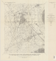
Map of part of Las Vegas Valley, Nevada, showing the approximate altitude of the water table in the near-surface reservoir in February 1956
Date
1965
Description
Genre/Form: Thematic maps. Scale 1:62,500 (W 115°15´--W 115°00´/N 36°15´--N 36°00´). 1 map ; 45 x 36 cm. Series: Water-supply paper (Washington, D.C.) ; 1780. Relief shown by contours. Originally published as plate 8 of Available water supply of the Las Vegas ground-water basin, Nevada, by Glenn T. Malmberg, published by the Geological Survey in 1965 as its Water-supply paper 1780. Includes township and range lines. Interior, Geological Survey
Image

Official Arrow city map, Las Vegas & vicinity, Nevada, circa 1957-1961
Date
1957 to 1961
Description
71 x 68 cm. on sheet 106 x 71 cm., folded in cover 25 x 12 cm. Cover title: Latest edition, city map and street index of "fabulous" Las Vegas and vicinity, Nevada. Publisher from cover. "H-654-32." Includes indexes. Inside of cover includes information on Las Vegas. Includes inset maps of Boulder City, Nevada, and Las Vegas's location. Original publisher: R. L. Polk.
Image

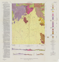
Geologic map of the Paiute Ridge quadrangle, Nye and Lincoln Counties, Nevada, 1967
Date
1967
Description
58 x 46 cm., on sheet 85 x 83 cm., fold. in envelope 30 x 24 cm. Relief shown by contours and spot heights. "Contour interval 20 feet." "Prepared in cooperation with the U.S. Atomic Energy Commission." "Geology mapped in 1961. Contours on pre-Tertiary rocks by D. L. Healey and C. H. Miller, 1963." Includes text, 4 col. cross sections, and quadrangle location map. Original publisher: U. S. Geological Survey, Series: Geologic quadrangle map GQ, Scale: 1:24 000.
Image

Geologic map of the Lathrop Wells quadrangle, Nye County, Nevada, 1970
Date
1970
Description
58 x 47 cm., on sheet 74 x 84 cm., folded in envelope 30 x 24 cm. Relief shown by contours and spot heights. "Bedrock geology mapped by B.C. Burchfiel, 1961, and by E.J. McKay and K.A. Sargent, 1965-66. Surficial geology mapped by A.T. Fernald, 1968." Includes cross sections, description of map units, and location map. "Prepared in cooperation with the U. S. Atomic Commission." Original publisher: Interior, Geological Survey, Series: Geologic quadrangle map GQ, Scale: 1:24 000.
Image

Geologic map of the Dead Horse Flat quadrangle, Nye County, Nevada, 1967
Date
1967
Description
58 x 46 cm., on sheet 77 x 84 cm., folded in envelope 30 x 24 cm. Relief shown by contours and spot heights. "Base by U.S. Geological Survey, 1960." "Geology mapped in 1962-64." "Contour interval 20 feet." Includes 2 col. cross sections, quadrangle location map, and text. "Prepared in cooperation with the U. S. Atomic Commission." Original publisher: Interior, Geological Survey, Series: Geologic quadrangle map GQ, Scale: 1:24 000.
Image

Geologic map of the Topopah Spring quadrangle, Nye County, Nevada, 1970
Date
1970
Description
58 x 46 cm., on sheet 84 x 88 cm., folded in envelope 30 x 24 cm. Relief shown by contours and spot heights. "Geology mapped in 1962-63." Includes description of map units, colored columnar section, 3 colored cross sections, and quadrangle location map. "Prepared in cooperation with the U. S. Atomic Commission." Original publisher: Interior, Geological Survey, Series: Geologic quadrangle map GQ, Scale: 1:24 000.
Image

Geologic map of the Tippipah Spring quadrangle, Nye County, Nevada, 1963
Date
1963
Description
58 x 46 cm., on sheet 84 x 81 cm., folded in envelope 30 x 24 cm. Relief shown by contours and spot heights. "Geology by P.P. Orkild, 1959-60, paleotopography by D.L. Healey and C.H. Miller, 1959-60." Series statement from envelope. Includes description of map units, 2 col. cross sections, and quadrangle location map. "Prepared in cooperation with the U. S. Atomic Commission." Original publisher: Interior, Geological Survey, Series: Geologic quadrangle map GQ, Scale: 1:24 000.
Image
Geology of the Oak Spring Quadrangle, Nye County, Nevada, 1963
Date
1963
Description
58 x 46, on sheet 88 x 84 cm., fold. in envelope 30 x 24 cm. Relief shown by contours and spot heights. "Contour interval 20 feet." "Prepared in cooperation with the U.S. Atomic Energy Commission." Title on envelope: Geologic map of the Oak Spring Quadrangle, Nye County, Nevada. Includes 3 col. cross sections, text, and quadrangle location map. Original publisher: Interior, Geological Survey, Series: Geologic quadrangle map GQ, Scale: 1:24 000.
Image

Geologic map of the northeast quarter of the Bullfrog 15-minute quadrangle, Nye County, Nevada, 1990
Date
1990
Description
58 x 46 cm., on sheet 87 x 102 cm., folded in envelope 30 x 24 cm. Relief shown by contours and spot heights. "Contour interval 40 feet." "Base from U.S. Geological Survey 1:62,500. 1954." "Geology mapped in 1985 and 1988." Includes text, bibliography, 4 col. cross sections, and location and index maps. "Prepared in cooperation with the U. S. Atomic Commission." Original publisher: U. S. Geological Survey, Series: Miscellaneous investigations series, map I, Scale: 1:24 000.
Image